A revolutionary one-point infrastructure bringing the full power of drone technology to every village in India — sales, rental, training, repair, and drone-port operations, all under one roof.
Four distinct franchise tiers — each designed for a different scale of operation, territory, and investment level. Find the right fit for your ambition.
POPULAR
TIER 02 · PANCHAYAT LEVEL
🏪
HAL CENTER
Hyperlocal Agri-tech & Logistics
A compact digital innovation hub offering drone sales, rental, training, and repair at village/panchayat level. Ideal for local entrepreneurs with a dedicated territory radius.
✓ Drone sales, rental & repair
✓ Digital Smart Kiosk
✓ HAL ERP platform access
✓ Revenue sharing model
INVESTMENT
₹5–15L
EXPLORE →
TIER 03 · BLOCK / TEHSIL
🏬
VAIGO CENTER
Village Agri-Intelligence & Growth Ops
A mid-scale block/tehsil-level hub combining drone showroom, EV mobility bays, agri services desk, and solar installation sales — for multi-income operators targeting a broader area.
✓ Drone showroom & demo area
✓ EV mobility hub (2-bay)
✓ Agri services + solar sales
✓ Block-level territory rights
INVESTMENT
₹15–30L
EXPLORE →
TIER 04 · DISTRICT ZONE
🚁
MEGHDEV DRONE STATION
Full 1-Acre Drone Operations Hub
A full-scale 1-acre drone operations center with DGCA-compliant port, all 5 service divisions, solar power, charging bays, and training lab. District-level exclusive territory.
✓ Full 1-acre station setup
✓ DGCA certification support
✓ All 5 service divisions active
✓ HAL ERP + equipment supply
INVESTMENT
₹18–45L
EXPLORE →
PREMIUM
TIER 05 · DISTRICT FLAGSHIP
⬡
FAME HUB
Farming · Aerospace · Mobility · Energy
The flagship district-level hub integrating drone port, EV charging bays, solar installation, and agri-intelligence under one roof. Limited to 1–2 per district. Maximum revenue potential.
✓ Complete 1-acre container hub
✓ Drone Port + EV + Solar
✓ Sub-franchise & HAL integration
✓ 1–2 per district · max exclusivity
INVESTMENT
₹45L–1Cr
EXPLORE →
Not sure which tier suits you?
View all membership tiers, network map, and onboarding steps →
HAL CENTER — LIVE SYSTEM
India's Digital Rural Hub at Block Level
The HAL Center is a compact yet fully-equipped drone intelligence hub deployable at Gram Panchayat level. Powered by solar energy, managed via the HAL ERP platform, and anchored by a Digital Smart Kiosk — it brings agri-tech, logistics, and digital services to the last mile of India.
27+
ACTIVE HAL CENTERS
18+
UP DISTRICTS COVERED
35K+
ACRES SERVED
80+
DGCA PILOTS TRAINED
📱
DIGITAL KIOSK
Touchscreen kiosk for farmer self-service — booking, payments, scheme enrolment in Hindi & regional languages.
🛰️
HAL ERP CONNECTED
Every HAL center runs on cloud-synced ERP for real-time fleet tracking, crop intelligence, and revenue analytics.
☀️
SOLAR-POWERED
Fully solar-powered with LiFePO4 battery backup ensuring 8-12 hours of off-grid operation at every HAL center.
🌐
ALWAYS CONNECTED
4G/5G + VSAT satellite failover + ADS-B beacon ensuring continuous uptime even in the most remote locations.
// ABOUT MEGHDEV
India's First Village-Level Drone Hub
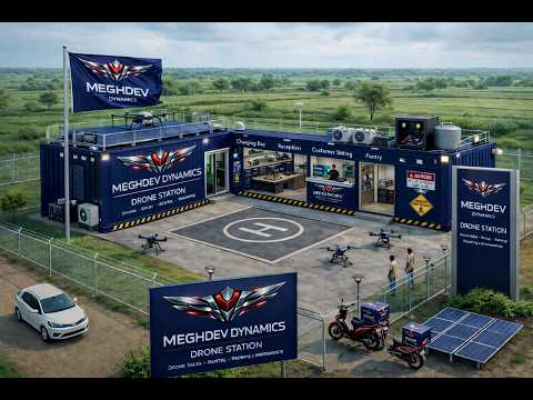
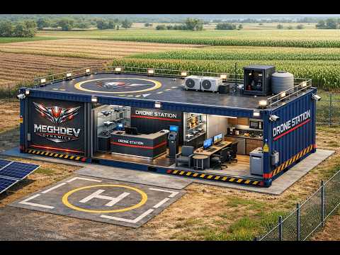
◆ MEGHDEV DYNAMICS DRONE STATION — CONCEPTUAL VIEW
Revolutionary One-Point Drone Infrastructure Hub
MEGHDEV DRONE STATION — Village Aerial Innovation & Growth Operations Center — is designed as a 1-acre modular facility acting as the local command and support node for all drone-related activities across rural India.
Developed by Ojas Aerospace Private Limited, each station functions as a miniaturized "airport for drones" — the bridge between technology creators, rural users, and national drone missions, empowering youth, women, and entrepreneurs.
◆ OUR MISSION
To democratize aerial technology at the grassroots level — creating scalable, profitable drone infrastructure businesses for entrepreneurs across every village, block, and district of India, while transforming agriculture, logistics, healthcare, and rural connectivity.
◆ OUR VISION
Digital Bharat, Developed Bharat — utilizing Drones, Robots, AI, and Deep Tech at the grassroots level to create one-stop solutions across the country. India's most advanced agri-intelligence and rural deeptech network by 2030.
🏗️
Modular Design
Rapidly deployable
☀️
Solar Powered
Off-grid operations
📡
ADS-B Beacon
Full air awareness
🤖
AI Integration
Smart analytics
// CONCEPTUAL DESIGN · AERIAL VIEW
Our Drone Station Infrastructure
Purpose-built containerised drone hubs deployable anywhere in India — from rural farmlands to district headquarters.
AERIAL STATION VIEW
Charging Bay · Reception · Customer Sitting · Helipad
◆ DRONE STATION · OUTDOOR COMPLEX
Full compound with helipad, solar panels, security fencing & signage
REPAIR BAY · COMMAND CENTER
Repair Workshop · Front Desk · Charging Bay · Solar Panels
◆ DRONE STATION · REPAIR & COMMAND HUB
Full repair bay, command desk, workstations & roof helipad with perimeter lighting
⬡ CONTAINERISED DESIGN
⬡ ROOF HELIPAD READY
⬡ SOLAR POWERED
⬡ DEPLOYABLE ANYWHERE
// FIELD TEAM · WOMEN IN DRONES
Empowering Rural Women as Drone Operators
Meghdev Dynamics is pioneering women-led drone services across India — trained drone pilots and field engineers working at the last mile of agriculture, delivery, and rural tech.
MOBILE DRONE DELIVERY
Last-mile agri-drone service on Meghdev Dynamics branded scooter
◆ MEGHDEV FIELD OPERATOR
Certified drone pilot on EV delivery scooter with branded drone deployment kit
CERTIFIED DRONE TEAM
Trained women engineers in full Meghdev Dynamics operational uniform
◆ MEGHDEV CERTIFIED PILOTS
DGCA-trained women drone operators ready for agri-spraying, surveying & delivery
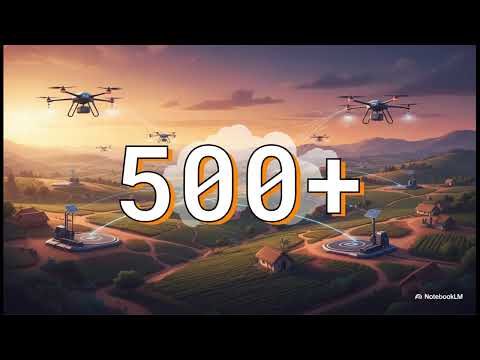
500+
WOMEN OPERATORS
Trained & Deployed
28
STATES COVERED
Field Network
DGCA
CERTIFIED TRAINING
Govt Approved
12+
SERVICES PER PILOT
Revenue Streams
// CORE SERVICES
Complete Drone Ecosystem
Click any service card to explore detailed information, processes, and specifications.
SVC-01
🚁
DRONE SALES
Authorized dealership for agricultural, industrial, photography, and surveillance drones with complete accessories and spare parts ecosystem.
AGRI DRONESINDUSTRIALPHOTOGRAPHYACCESSORIES
EXPLORE ▶
SVC-02
📋
RENTAL & LEASING
Pay-per-use or subscription-based drone rental for farmers, surveyors, photographers, and government departments with flexible seasonal plans.
DAILY RENTALSUBSCRIPTIONSEASONAL
EXPLORE ▶
SVC-03
🎓
TRAINING & CERTIFICATION
DGCA-approved training programs with simulation labs, classrooms, and certified instructors for pilot certification and data analysis courses.
DGCA APPROVEDSIM LABCERTIFICATION
EXPLORE ▶
SVC-04
🔧
REPAIR & MAINTENANCE
Fully equipped portable workshop cabin for assembly, diagnostics, calibration, and spare-part replacement for all drone types and brands.
DIAGNOSTICSCALIBRATIONSPARE PARTS
EXPLORE ▶
SVC-05
🛫
DRONE PORT OPERATIONS
Fenced, geo-tagged take-off/landing pad with charging infrastructure, ADS-B beacon, and weather station for daily commercial operations.
LAUNCH PADADS-BCHARGINGWEATHER STA.
EXPLORE ▶
SVC-06
🌾
PRECISION AGRICULTURE
Crop monitoring, precision spraying with 10–70L payload, pest detection, soil testing, and AI-powered advisory services for modern farming.
CROP MAPPINGSPRAYINGSOIL TESTINGAI ADVISORY
EXPLORE ▶
SVC-07 · PREMIUM
⬡
FAME HUB
Farming · Aerospace · Mobility · Energy — India's first container-based district technology hub with EV charging, solar installation, and full drone ops.
EV CHARGINGSOLARPREMIUM
EXPLORE FAME HUB ▶
// APPLICATION SECTORS
Serving Every Industry
Click any sector to explore industry-specific drone applications, use cases, and outcomes.
🌾
AGRICULTURE
Spraying, mapping, and pest detection for precision farming and cost reduction
LEARN MORE ▶
📸
PHOTOGRAPHY
Event, tourism, and real-estate aerial coverage creating local enterprise
LEARN MORE ▶
📦
LOGISTICS
Medical, e-commerce, and agri-input transport for rural connectivity
LEARN MORE ▶
🏭
INDUSTRIAL
Power lines, construction, and irrigation audits for safety and maintenance
LEARN MORE ▶
🛡️
SECURITY
Emergency monitoring, fire watch, and flood rescue for community resilience
CONTAINER SPECS · LAND REQUIREMENTS · DRONE PORT · PROCUREMENT
// MARKET PROJECTIONS
Transforming Rural India
₹21M
PROJECTED REVENUE BY YEAR 1
18–32%
MARKET CAGR
$30B
GLOBAL AGRI DRONE MARKET 2034
3 YRS
TO PROFITABILITY
70L
MAX PAYLOAD CAPACITY
CM
PRECISION ACCURACY
💼
EMPLOYMENT CREATION
Setting up and operating a Drone Station creates diverse roles — from certified drone pilots to maintenance technicians — generating employment across multiple skill levels in rural communities.
🏥
HEALTHCARE & SOCIAL EQUITY
Drones enable swift delivery of medical supplies, remote patient monitoring, and rapid emergency response — particularly critical in hard-to-reach and underserved areas of India.
🌿
ENVIRONMENTAL MONITORING
Precise environmental monitoring enables early detection of deforestation, pollution, and ecological threats — enabling timely interventions and promoting sustainable agricultural practices.
// MEGHDEV IN ACTION
Watch the System Work
See Meghdev's drone network, HAL Centers, field operations, and technology in action — click any video to watch on YouTube.
Hal Center is a unique initiative by Ojas Aerospace that promotes technological innovation at the grassroots level to realize the vision of "Digital Bharat, Developed Bharat." It is a multi-utility digital innovation and experience hub designed to offer a wide range of products and services to farmers, retailers, brands, logistics providers, self-employed individuals, and government institutions.
Through the Hal Center, all drone-related needs are addressed, including drone sales, rentals, training, repair, and maintenance. It offers specialized drones for photography, agriculture, logistics, and industrial operations. Through a single Digital Smart Kiosk, Hal Center facilitates seamless access across the full spectrum.
Drone Sales & Rentals
Drone Training & Repair
Crop Health Monitoring
Precision Farming
Soil & Crop Testing
Agri-Input Sales
Govt-to-Citizen Services
Rural Entrepreneurship
"Digital Bharat, Developed Bharat."
Ojas Aerospace & i369 Innovation are creating one-stop solutions across the country by utilizing Drones, Robots, AI, and Deep Tech at the grassroots level. Hal Center is a multi utility digital innovation & experience center for shopping, exploring, awareness and services across the spectrum. With one Digital Smart Kiosk, Hal Center is facilitating products and services to Farmer, Retailer, Brand, Logistics, Self Employed and Government Institutions.
The MEGHDEV DRONE STATION partnership opportunity is open to individuals and entities with a variety of backgrounds and aspirations.
🚀
ENTREPRENEURS
Individuals with an entrepreneurial spirit looking to invest in and operate a business in the rapidly growing drone industry. Build your own drone station franchise.
🏢
EXISTING BUSINESSES
Established business owners seeking to expand their portfolio into the drone sector. Leverage your existing infrastructure and customer base with drone services.
🌾
AGRI CO-OPERATIVES
Farmer collectives and agricultural cooperatives looking to modernize operations with precision drone technology and collective buying power.
🏛️
GOVERNMENT BODIES
State and central government departments seeking drone infrastructure for agriculture, disaster management, surveillance, and rural development programs.
🎓
EDUCATION INSTITUTES
Schools, colleges, and vocational training centers wanting to integrate drone technology into their curriculum and create DGCA-certified drone pilots.
💡
TECH INNOVATORS
Startups and tech companies developing agri-AI, IoT, and drone software solutions looking for ground-level deployment infrastructure across rural India.
// BEGIN YOUR MISSION
Ready to Launch Your Drone Station?
Join India's largest rural drone network. Bring aerial innovation to your district and be part of the Digital Bharat revolution.
Fill in the details below to register your interest. Our team will contact you within 3–5 business days.
MEGHDEVDYNAMICS
DRONE STATION APPLICATION
// CENTER FRANCHISE REGISTRATION FORM
APPLICATION REFMD-2024-XXXXX
◀ BACK TO HOME
MEGHDEVDYNAMICS
// SVC-01 · DRONE SALES
Drone Sales &Distribution Hub
Authorized dealership for the full spectrum of UAV technology — from agricultural spraying drones to industrial-grade survey platforms. We bring India's most advanced aerial technology to your doorstep.
10+
DRONE MODELS
70L
MAX PAYLOAD
48H
DELIVERY SUPPORT
AVAILABLE DRONE CATEGORIES
🌾 Agricultural Spraying₹2.5L – 18L
📸 Photography & Survey₹50K – 5L
🏭 Industrial Inspection₹5L – 30L
🚁 Logistics / Delivery₹3L – 20L
🛡️ Surveillance / Security₹8L – 40L
WHAT WE OFFER
🌾
AGRICULTURAL DRONES
High-capacity spraying drones (10–70L payload) with multi-directional obstacle avoidance, centimeter-level GPS accuracy, and intelligent flight planning for precision farming.
📸
PHOTOGRAPHY DRONES
High-quality aerial photography and videography drones for content creators, real estate professionals, event coverage, and tourism documentation.
🏭
INDUSTRIAL DRONES
Industrial-grade UAVs for infrastructure inspection, power line surveys, construction monitoring, and large-area mapping with advanced sensors and LiDAR integration.
🔩
ACCESSORIES & SPARES
Complete ecosystem of batteries, propellers, chargers, spraying nozzles, gimbal cameras, and all OEM spare parts for rapid maintenance and upgrades.
PURCHASE PROCESS
01
CONSULTATION & ASSESSMENT
Our drone experts assess your specific requirements — crop type, farm size, terrain, budget — and recommend the most suitable drone model and configuration.
02
DEMO FLIGHT
We conduct a live demonstration flight of the recommended drone at your location so you can evaluate performance before purchase.
03
DOCUMENTATION & DGCA REGISTRATION
We assist you with all DGCA registration requirements, UIN number, insurance, and all regulatory compliance for legal drone operation.
04
DELIVERY & SETUP
Drone delivered, assembled, and configured at your location. Our technicians ensure everything is flight-ready and you receive hands-on orientation.
05
AFTER-SALES SUPPORT
12-month warranty, dedicated support hotline, maintenance packages, and access to our nationwide network of service centers.
Ready to Purchase a Drone?
Visit your nearest Meghdev Drone Station or apply to become a partner and bring drone sales to your area.
Access the power of professional drones without the capital investment. Our flexible rental plans are designed for farmers, surveyors, photographers, and government departments of all scales.
₹800
FROM / DAY
24H
BOOKING LEAD TIME
3
RENTAL PLANS
RENTAL PLANS
DAILY RENTAL
₹800 – ₹3,500 / day
Ideal for seasonal or one-time needs
WEEKLY / MONTHLY
₹4,000 – ₹18,000 / week
Best for ongoing projects
SEASONAL SUBSCRIPTION
₹25,000 – ₹90,000 / season
Agricultural season packages
RENTAL INCLUDES
🚁
FULLY MAINTAINED DRONE
Pre-flight checked, calibrated, and ready-to-fly drone with fresh batteries and all required accessories included.
👨✈️
OPTIONAL PILOT SERVICE
Add a DGCA-certified pilot to your rental for professional operation — ideal if you don't have a drone license yet.
🛡️
INSURANCE COVERED
All rentals come with operational insurance coverage for accidental damage during the rental period.
📞
24/7 SUPPORT
Round-the-clock technical support during your rental period with rapid replacement guarantee in case of technical failure.
HOW TO RENT
01
CHOOSE YOUR DRONE & DATES
Contact your nearest Meghdev Drone Station and specify the drone type needed, dates, and whether you need a pilot service.
02
SUBMIT KYC & ADVANCE PAYMENT
Provide Aadhaar/PAN for identity verification and pay a refundable security deposit along with advance rental payment.
03
COLLECT & OPERATE
Collect the drone from the station or opt for doorstep delivery. Our team conducts a brief orientation before handover.
04
RETURN & DEPOSIT REFUND
Return the drone in good condition and receive your security deposit back. Damages are assessed and deducted transparently.
Start Renting Today
No capital investment needed. Access professional drone technology from just ₹800/day.
From zero to licensed drone pilot. Our DGCA-approved training programs equip students with theoretical knowledge, simulation practice, and real-world flight hours needed for certification.
DGCA
APPROVED
14
DAY PROGRAM
100%
PLACEMENT AID
COURSE MODULES
MODULE
DURATION
Drone Technology Basics
2 days
DGCA Regulations & Air Law
2 days
Simulator Flight Training
3 days
Live Flight Training
5 days
Data Analysis & Mission Planning
2 days
TRAINING PROGRAMS
🎓
BASIC REMOTE PILOT LICENSE
14-day comprehensive program for DGCA Remote Pilot Certificate. Covers theory, simulator practice, and minimum flight hours required for certification. Fee: ₹25,000 – ₹40,000.
🌾
AGRICULTURAL DRONE OPERATOR
Specialized 7-day program for farmers and agri-entrepreneurs on precision spraying, crop mapping, pest detection, and agri-drone maintenance. Fee: ₹15,000.
🔧
DRONE MAINTENANCE TECHNICIAN
10-day hands-on program on drone assembly, diagnostics, calibration, and repair. Includes practical assessment and technician certification. Fee: ₹20,000.
📊
DRONE DATA ANALYST
5-day program on drone data processing — orthomosaic mapping, NDVI analysis, 3D modelling, and report generation using GIS software. Fee: ₹12,000.
Become a Certified Drone Pilot
Transform your career with DGCA-approved drone training. Jobs await in agriculture, surveying, photography, and logistics.
Fully equipped portable workshop with specialized diagnostic tools, spare parts inventory, and trained technicians ensuring maximum drone uptime for your operations.
24H
TURNAROUND
500+
SPARE PARTS
ALL
BRANDS SERVICED
SERVICE MENU
SERVICE TYPE
ESTIMATED COST
Basic Service & Calibration
₹800 – ₹2,000
Motor Replacement
₹500 – ₹3,000
ESC / FC Replacement
₹1,500 – ₹8,000
Battery Replacement
₹3,000 – ₹20,000
Frame Repair / Replacement
₹1,000 – ₹15,000
Firmware Update & Optimization
₹500 – ₹1,500
REPAIR CAPABILITIES
🔍
ADVANCED DIAGNOSTICS
Multi-point diagnostic assessment using specialized software to identify motor, ESC, flight controller, GPS, and sensor issues with precision.
⚙️
FULL ASSEMBLY & REBUILD
Complete drone assembly, disassembly, and rebuild services. Structural repairs, frame replacement, and custom modification support.
📡
SENSOR & CAMERA SERVICE
Gimbal calibration, camera sensor cleaning, multispectral sensor servicing, LiDAR maintenance, and spray system nozzle replacement.
🔋
BATTERY HEALTH CHECK
LiPo battery cell balancing, capacity testing, and safe disposal. Battery reconditioning and replacement with genuine OEM packs.
Book a Service Appointment
Fast, reliable drone repair with genuine spare parts and certified technicians. 24-hour standard turnaround.
India's first village-level drone port infrastructure. A fully equipped, geo-tagged, ADS-B enabled UAV operations pad serving as the launch and coordination hub for all aerial missions in the region.
30×30
METER OPS PAD
6
CHARGING BAYS
ADS-B
BEACON V2
PORT INFRASTRUCTURE
Ops Pad Size30m × 30m
Helipad Pads2 Simultaneous
Charging Bays6 Simultaneous
BeaconADS-B V2
Weather StationReal-time Data
FencingFull Perimeter
PowerSolar + Grid Backup
PORT CAPABILITIES
🛫
MULTI-DRONE OPERATIONS
Coordinated take-off and landing for up to 4 drones simultaneously. Air traffic management within the geofenced perimeter ensures safe concurrent operations.
⚡
RAPID CHARGING STATION
6 simultaneous charging bays with fast-charging support for LiPo and LiFePO4 batteries. Solar-powered with grid backup for 24/7 availability.
🌤️
WEATHER MONITORING
Real-time wind speed, direction, humidity, and temperature data to make informed go/no-go flight decisions and optimize mission windows.
📡
ADS-B INTEGRATION
Automatic Dependent Surveillance-Broadcast system providing real-time airspace situational awareness, ensuring DGCA compliance and collision avoidance.
Bring a Drone Port to Your District
Apply to establish India's first village-level UAV port and become the aerial hub of your region.
Revolutionizing Indian farming with drone-powered precision agriculture — crop monitoring, precision spraying, AI advisory, and digital farm management aligned with MahaAgri-AI Policy 2025–2029.
70L
PAYLOAD CAPACITY
CM
GPS ACCURACY
40%
CHEMICAL REDUCTION
AGRI DRONE SPECS
PARAMETER
SPECIFICATION
Spray Tank Capacity
10L / 20L / 40L / 70L
Spraying Width
4–8 meters
Coverage Rate
7–15 acres/hour
GPS Accuracy
±2cm (RTK)
Obstacle Avoidance
Multi-directional
Intelligent Path Planning
Autonomous
PRECISION FARMING SERVICES
🌱
CROP HEALTH MONITORING
Multispectral imaging generates NDVI, NDRE, and CWSI maps to identify crop stress, disease, pest damage, and irrigation deficiency at field scale.
💧
PRECISION SPRAYING
Variable-rate pesticide and fertilizer spraying with centimeter accuracy. 40% reduction in chemical usage vs. manual spraying with better coverage uniformity.
🗺️
FARM MAPPING & SURVEY
High-resolution orthomosaic maps, 3D terrain models, and farm boundary surveys for land record digitization and precision irrigation planning.
🤖
AI CROP ADVISORY
AI-powered platform analyzes satellite + drone data + weather to deliver personalized crop advisory, yield prediction, and input optimization for each farm pixel.
🧪
SOIL & CROP TESTING
On-site soil health testing (pH, NPK, organic matter) and leaf tissue analysis with recommendations for precision fertilization.
📦
AGRI-INPUT SALES
Seeds, pesticides, fertilizers, and agri-inputs at fair prices directly to farmers — eliminating middlemen and ensuring product quality.
Transform Your Farm with Drone Technology
Reduce costs, increase yield, and practice sustainable farming with precision drone agriculture.
Transforming India's agrarian heartland with UAV technology. From paddy fields of Punjab to sugarcane farms of Maharashtra — drones are making every acre more productive and every farmer more prosperous.
15ac
COVERAGE / HOUR
40%
LESS CHEMICALS
25%
YIELD INCREASE
🌾
USE CASES IN AGRICULTURE
🌱
CROP MONITORING
Weekly NDVI flights to track crop health across entire farms in minutes. Early detection of disease, pest attack, or nutrient deficiency before visible symptoms appear.
💧
PRECISION SPRAYING
GPS-guided pesticide and fertilizer spraying with variable rate application. Achieve uniform coverage even on irregular terrain, reducing input costs by up to 40%.
🌿
SEEDLING PLANTATION
Aerial seeding for paddy, cover crops, and reforestation at 10x the speed of manual planting. Ideal for flooding-prone or difficult-access fields.
🗺️
LAND SURVEYING & MAPPING
Centimeter-accurate farm maps for land records, irrigation design, boundary demarcation, and agricultural insurance claim documentation.
📊
YIELD ESTIMATION
AI-powered crop counting and yield prediction 4–6 weeks before harvest. Helps farmers plan logistics, storage, and market timing for maximum profit.
🚜
LIVESTOCK MONITORING
Aerial monitoring of large grazing areas, cattle count, and health assessment without time-consuming manual ground surveys.
CROP-SPECIFIC APPLICATIONS
CROP
DRONE APPLICATION
KEY BENEFIT
🌾 Wheat
Fungicide spraying, crop mapping
30% reduction in rust disease losses
🌾 Rice / Paddy
Aerial seeding, fertilizer application
Saves 50% water, doubles planting speed
🎋 Sugarcane
NDVI monitoring, pest detection
15% yield increase (MahaAgri-AI)
🌿 Cotton
Bollworm monitoring, precision spray
40% pesticide reduction
🌻 Soybean
Crop health, disease scouting
Early detection increases profit by 20%
🍎 Orchards
Canopy mapping, spray under canopy
Uniform coverage impossible by hand
Bring Drone Farming to Your Village
Partner with Meghdev to establish precision agriculture services in your area.
Unlock breathtaking aerial perspectives for events, tourism, real estate, and media production. The Meghdev Drone Station empowers local entrepreneurs to build thriving aerial photography businesses.
4K
VIDEO CAPTURE
48MP
IMAGE RESOLUTION
45min
FLIGHT TIME
📸
PHOTOGRAPHY & MEDIA USE CASES
🏠
REAL ESTATE
Aerial photography and video tours of residential and commercial properties, land parcels, and township projects to attract premium buyers and investors.
💒
WEDDINGS & EVENTS
Cinematic aerial coverage of weddings, festivals, corporate events, and cultural ceremonies creating memorable keepsakes and promotional content.
🏛️
TOURISM & HERITAGE
Showcase temples, forts, rivers, forests, and natural landscapes for tourism promotion, creating compelling visual content for state tourism boards.
📺
MEDIA PRODUCTION
News gathering, documentary filmmaking, advertisement production, and film shoots requiring dynamic aerial shots previously possible only with helicopters.
Start Your Aerial Photography Business
Build a profitable aerial photography venture with support from the Meghdev Drone Station network.
Breaking the last-mile connectivity barrier in rural India. Drone-based delivery of medicines, agri-inputs, and e-commerce packages to villages unreachable by road in adverse weather or terrain.
25km
DELIVERY RANGE
5kg
PAYLOAD
30min
DELIVERY TIME
📦
LOGISTICS APPLICATIONS
💊
MEDICAL SUPPLY DELIVERY
Emergency delivery of medicines, blood, vaccines, and medical equipment to remote PHCs and villages. Critical during monsoon season when roads are cut off.
🛒
E-COMMERCE LAST MILE
Deliver e-commerce packages to villages and hamlets unreachable by conventional delivery. Partner with Flipkart, Amazon, and Meesho for last-mile drone delivery.
🌾
AGRI-INPUT DELIVERY
On-demand delivery of seeds, pesticides, fertilizers, and farming tools directly to farmgates. Eliminate farmer trips to town for urgent inputs.
🏦
FINANCIAL DOCUMENTS
Secure delivery of bank documents, government certificates, and legal papers eliminating long-distance travel for critical administrative tasks.
Launch Drone Delivery in Your Region
Be the first to bring drone logistics infrastructure to your district and create a new revenue stream.
Replacing dangerous manual inspections with safe, precise, and cost-effective drone surveys of power infrastructure, construction sites, solar farms, and water bodies.
0
HUMAN RISK
10×
FASTER INSPECTION
60%
COST REDUCTION
🏭
INDUSTRIAL USE CASES
⚡
POWER LINE INSPECTION
Thermal and visual inspection of high-voltage transmission lines, insulators, and tower structures. Detect hotspots, corrosion, and structural damage without outages.
🏗️
CONSTRUCTION MONITORING
Progress monitoring, volumetric calculations, safety compliance checks, and stakeholder reporting through regular aerial surveys of construction sites.
☀️
SOLAR FARM INSPECTION
Thermal imaging to identify faulty panels, hot spots, and soiling patterns across solar installations. Optimize cleaning schedules and maintenance resources.
💧
IRRIGATION & WATER AUDIT
Survey of canal networks, irrigation channels, and reservoir conditions. Monitor water distribution efficiency and identify seepage and blockages.
Bring Industrial Drone Services to Your Area
Tap into the growing demand for industrial inspection services with Meghdev's technology platform.
Protecting communities with aerial intelligence. From wildfire early detection to flood rescue coordination — Meghdev Drone Stations serve as rapid-response aerial infrastructure for community safety.
5min
DEPLOYMENT TIME
IR
THERMAL IMAGING
8km
COMM. RANGE
🛡️
SECURITY & DISASTER USE CASES
🔥
FIRE WATCH & MONITORING
Early detection of field fires, forest fires, and industrial fires using thermal imaging drones. Real-time feeds to local fire brigades and district control rooms.
🌊
FLOOD RESCUE SUPPORT
Aerial mapping of flood-affected areas, locating stranded individuals, dropping emergency supplies, and coordinating rescue teams with real-time aerial intelligence.
👁️
CROWD & EVENT MONITORING
Aerial surveillance for festivals, elections, and large public gatherings. Provide law enforcement with real-time situational awareness and crowd density monitoring.
🔍
SEARCH & RESCUE
Night-time thermal drone search for missing persons in forests, agricultural fields, and disaster zones. Cover in hours what ground teams take days to search.
Make Your Community Drone-Ready
Establish a Meghdev Drone Station to give your community rapid aerial response capability for emergencies.
The Meghdev Drone Station Network is expanding across every district of India. Join as an operator, partner, investor, or franchise owner and be at the forefront of India's aerial revolution.
500+
TARGET STATIONS
28
STATES COVERED
₹21M
YEAR 1 REVENUE
NETWORK STATUS
Active Stations47 LIVE
In Setup23 PENDING
Applications186 REVIEW
States Active12 / 28
43% OF 2025 TARGET ACHIEVED
MEMBERSHIP TIERS
TIER 01 · ENTRY
ASSOCIATE
FREE forever
✓ Digital Member ID & certificate
✓ Network newsletter & reports
✓ Attend Meghdev events
✓ Community forum access
✓ Industry briefings & data
✗ Revenue sharing
✗ Franchise rights
POPULAR
TIER 02 · OPERATOR
HAL CENTER
₹5–15L investment
✓ HAL Operations Center setup
✓ Meghdev brand license
✓ Drone operations training
✓ Equipment supply access
✓ Marketing & onboarding support
✓ Revenue sharing model
✗ Full station rights
TIER 03 · BLOCK / TEHSIL
VAIGO CENTER
Block / Tehsil Territory
₹15–30L investment
✓ Drone showroom & demo area
✓ EV mobility hub (2-bay)
✓ Agri services desk
✓ Solar installation sales
✓ Tech training center
✓ Block-level area territory
TIER 04 · DISTRICT ZONE
MEGHDEV DRONE STATION
₹18–45L investment
✓ Full Drone Station (1-acre)
✓ DGCA certification support
✓ All 5 service divisions
✓ Equipment supply chain
✓ Defined area radius territory
✓ HAL ERP platform access
PREMIUM
TIER 05 · DISTRICT FLAGSHIP
FAME HUB
Farming · Aerospace · Mobility · Energy
₹45L–1Cr investment
✓ Complete 1-acre container hub
✓ Drone Port + DGCA ops
✓ EV sales, service & charging bays
✓ Solar installation (10–100 kW)
✓ 1–2 per district only
✓ Sub-franchise & HAL integration
✓ Full ERP + FAME Ops App
NETWORK BENEFITS
🤝
AREA TERRITORY RIGHTS
Each franchise is allocated a defined area/radius territory — not district-wide exclusivity. Your allocated territory is exclusively yours. No same-tier center can be set up within your boundary. FAME Hub limited to 1–2 per district.
📊
ERP PLATFORM ACCESS
Full access to HAL ERP Business Intelligence Platform — manage bookings, track revenue, monitor drone fleet, and generate reports from a single dashboard.
🎓
TRAINING & ONBOARDING
Comprehensive 2-week onboarding program at our regional training centers. Ongoing support through certified trainers, webinars, and field visits.
📣
BRAND & MARKETING
Leverage the Meghdev Dynamics brand, marketing collateral, digital campaigns, and national-level PR for your station. We grow together.
🔗
SUPPLY CHAIN ACCESS
Direct access to drone manufacturers, agri-input companies, spare parts distributors, and government scheme quotas at partner pricing.
💰
REVENUE SHARING
Structured revenue sharing model across services. Earn from drone sales commissions, rental fees, training fees, agri-spraying service charges, and govt contracts.
Everything happening in the Meghdev ecosystem — brand announcements, achievements, media coverage, podcast episodes, social buzz, government recognition, and live alerts from across India's growing drone network.
47+
MEDIA STORIES
12
NATIONAL AWARDS
8
PODCAST EPISODES
50K+
SOCIAL REACH
● LIVE UPDATE
Network Milestone Reached: Meghdev HAL Center network now covers 27 districts across 3 states — expanding to 50+ districts by Q3 2025.
TODAY · 09:41 IST
25
MAR
2025
MEGHDEV EXPANDS TO 5 NEW STATES — Q1 2025
Meghdev Dynamics announces the addition of Odisha, Jharkhand, Chhattisgarh, Assam, and Himachal Pradesh to its active franchise network, bringing the total active state count to 12 and establishing presence in Eastern and North-Eastern India.
EXPANSIONNETWORK
10
MAR
2025
HAL ERP PLATFORM v3.0 — LIVE FOR ALL PARTNERS
The HAL ERP Business Intelligence Platform v3.0 is now live for all Franchise and Premium Hub partners. Features include real-time drone fleet tracking, booking management, revenue analytics, and Firebase-powered cloud sync with 99.9% uptime SLA.
TECHNOLOGYPLATFORM
15
FEB
2025
DGCA APPROVES MEGHDEV AS RPTO — NATIONWIDE
Meghdev Dynamics has received DGCA approval as a Remote Pilot Training Organisation (RPTO), enabling all Drone Stations with Training divisions to issue DGCA-certified pilot licenses directly to graduates.
REGULATORYCERTIFICATION
28
JAN
2025
NAGPUR DRONE STATION — FIRST 1-ACRE FAME HUB LAUNCHED
India's first Meghdev Premium Hub is now operational in Nagpur, Maharashtra. The 1-acre facility includes all 5 divisions, a dual helipad, 6 charging bays, ADS-B beacon, and DGCA-approved training lab with capacity for 50 students per batch.
MILESTONELAUNCH
08
JAN
2025
i369 INNOVATION LTD — UK ENTITY OPERATIONAL
Founder Devesh Kumar Jha's UK-incorporated entity i369 Innovation Limited is now fully operational, enabling international partnerships, UK-India technology corridors, and cross-border rural-tech collaboration under Meghdev's global expansion strategy.
INTERNATIONALUK
BRAND STORY · IDENTITY · POSITIONING
The MEGHDEV Story — Rural India's Aerial Future
MEGHDEV — meaning "Cloud Lord" in Sanskrit — was named to reflect the company's mission: to build India's sky-based infrastructure for the 600+ million rural Indians who have never had access to aerial services. Founded from the ground up in 2019, Meghdev began not as a corporate initiative but as a ground-level response to India's most pressing agri-tech gap.
Today it is India's most ambitious village-level drone hub network — designed by an entrepreneur who has spent 16+ years building businesses across publishing, aviation, research and rural technology, and who was recognized in the United Kingdom as a standout entrepreneur.
BRAND PILLARS
▸Rural-first drone infrastructure at panchayat level
▸Franchise model empowering local entrepreneurs
▸Precision agri-tech democratized at farmer level
▸Earned credibility — PM recognition, ICMR, ICAR
▸Internationally recognized founder & structure
BRAND PORTFOLIO
MEGHDEV
Consumer brand · Drone hubs
VAiGO
Platform brand · Agri network
HAL ERP
SaaS platform · Enterprise
i369
UK entity · International
15
JAN
2025
VAIGO BRAND LAUNCHED — NATIONAL AGRI DRONE PLATFORM
Meghdev officially launches the VAiGO brand — Village Agri-Intelligence & Growth Operations — as the umbrella consumer platform for all agri-drone services, crop intelligence, farmer advisory, and 831-district HAL center deployment under one national identity.
BRAND LAUNCH
KEY ACHIEVEMENTS · MILESTONES · IMPACT NUMBERS
🏆
PM RECOGNITION — INDIA'S FIRST VACCINE DRONE
In 2021, Meghdev's parent Daybest Research executed India's very first drone-based vaccine delivery at Karang Island, Manipur under the ICMR iDrone project — praised personally by the Honourable Prime Minister of India and recognized globally by WHO.
NATIONAL LANDMARK
🌾
35,000+ ACRES SPRAYED ACROSS INDIA
Over 35,000 acres of agricultural land across rice, wheat, sugarcane, mustard, and vegetable belts have been precision-sprayed by Meghdev's fleet — from Jammu & Kashmir to Karnataka — saving farmers 40–60% on agri-input costs.
FARM IMPACT
🚀
MICROSOFT · AWS · T-HUB STARTUP SELECTION
Meghdev/Daybest Research was selected by Microsoft Startup Program, Amazon Web Services Drone Cohort, and T-Hub Hyderabad — placing the company among India's top-tier deep-tech drone startups validated by global accelerators.
GLOBAL RECOGNITION
🎓
80+ DGCA CERTIFIED PILOTS TRAINED
Through Meghdev's DGCA-authorized Remote Pilot Training Organisation (RPTO), over 80 pilots have been trained and certified — building India's rural drone workforce, many of whom are now operating HAL centers as resident pilots and entrepreneurs.
SKILL INDIA
🏗️
27 HAL CENTERS OPERATIONAL IN UP
A network of 27 fully operational drone service centers across 18+ districts of Uttar Pradesh — making Meghdev India's largest sub-district drone center operator, with each center serving hundreds of farmers per season.
NETWORK SCALE
🌍
UK ENTITY — i369 INNOVATION LTD
Founder Devesh Kumar Jha, drawing on his 16+ years spanning publishing, aviation, research and rural tech, incorporated i369 Innovation Limited in the United Kingdom — making Meghdev one of very few India-origin drone startups with a formal international holding structure.
INTERNATIONAL
AWARDS · RECOGNITIONS · GOVERNMENT HONOURS · REWARDS
🏅
PRIME MINISTER OF INDIA — PERSONAL RECOGNITION
Meghdev's parent company Daybest Research was personally recognized by the Honourable Prime Minister of India for leading India's first drone-based vaccine delivery mission at Karang Island, Manipur under the ICMR iDrone initiative (2021). A landmark achievement cited in national drone policy discourse.
GOVERNMENTNATIONAL HONOUR
🌍
WHO — WORLD HEALTH ORGANIZATION — RECOGNITION
The World Health Organization recognized India's first drone vaccine delivery at Karang Island — a mission executed by Meghdev/Daybest Research — as a pioneering use case for drone-enabled last-mile health logistics in emerging economies.
WHOGLOBAL HEALTH
🔬
ICMR & ICAR APPRECIATION
The Indian Council of Medical Research (ICMR) and Indian Council of Agricultural Research (ICAR) both formally appreciated Meghdev's contributions — ICMR for the iDrone vaccine program and ICAR for precision agriculture drone deployment across diverse crop and agro-climatic zones.
ICMRICAR
💻
MICROSOFT STARTUP PROGRAM — SELECTED
Daybest Research / Meghdev was selected into the Microsoft Startup Program, gaining access to Azure cloud credits, co-sell opportunities, and mentorship from Microsoft's enterprise ecosystem — validating Meghdev's technology architecture and product vision.
MICROSOFTSTARTUP
☁️
AMAZON AWS DRONE COHORT & T-HUB HYDERABAD
Selected by Amazon Web Services as part of its dedicated drone startup cohort, and by T-Hub Hyderabad — India's largest startup incubator — placing Meghdev alongside India's most innovation-forward drone companies in both programs.
AWST-HUB
PRESS COVERAGE · FEATURED ARTICLES · MEDIA APPEARANCES
18
MAR
2025
ECONOMIC TIMES · AGRI-TECH
MEGHDEV DYNAMICS: HOW A BIHAR ENTREPRENEUR IS BRINGING DRONE TECH TO INDIA'S FIELDS
Feature story on Meghdev Dynamics' journey from a one-person drone startup in 2019 to a 27-center network spanning UP — and the vision of one rural entrepreneur who crossed over from publishing and aviation into precision agriculture.
FEATURE STORYAGRI-TECH
02
MAR
2025
HINDUSTAN TIMES · INDIA
INDIA'S DRONE REVOLUTION REACHES THE LAST MILE — VAIGO & MEGHDEV NETWORK
National daily covers how Meghdev's HAL Center model is operationalizing the government's drone policy at the grassroots — with specific coverage of the 27-center UP network and India's first RPTO-certified drone training in rural districts.
NATIONAL PRESS
20
FEB
2025
DRONE TECH INDIA · INDUSTRY
FAME HUB: THE 1,200-STATION CONTAINER DRONE REVOLUTION COMING TO INDIA BY 2030
Industry deep-dive into Meghdev's FAME Hub model — container-based, solar-powered, ERP-connected drone stations deployable in 30 days — and how the company plans to cover 831 priority districts with franchise partnerships by 2030.
INDUSTRY PRESS
10
FEB
2025
NDTV RURAL · BROADCAST
DRONE DRONES REACH RURAL UP — MEGHDEV'S HAL SATHI CENTERS SERVE THOUSANDS OF FARMERS
NDTV Rural segment featuring on-ground reporting from Meghdev HAL centers in Uttar Pradesh — interviews with local pilots, farmers who have received drone spraying services, and the economics of the rural drone franchise model.
BROADCASTRURAL INDIA
VIDEO CONTENT · DOCUMENTARIES · FIELD FOOTAGE · DEMOS
▶
INDIA'S FIRST DRONE VACCINE DELIVERY — KARANG ISLAND
ICMR · iDrone Mission · Manipur, 2021
▶
HAL CENTER OPERATIONS — A DAY IN UP
Field Footage · Uttar Pradesh · 2024
▶
DRONE AGRI OPERATIONS — PRECISION FARMING
Field Demo · Meghdev Network · 2024
▶
MEGHDEV SYSTEM — PLATFORM WALKTHROUGH
System Demo · Meghdev Dynamics · 2025
▶
FAME HUB — CONTAINER DRONE STATION 2030
Infrastructure Vision · Meghdev · 2025
▶
IFFCO NANO-UREA SPRAYING — J&K TO KARNATAKA
Field Operations · IFFCO Partnership · 2023
▶
MEGHDEV DRONE NETWORK
Latest · Meghdev Dynamics
▶
MEGHDEV IN THE FIELD
Latest · Meghdev Dynamics
📹
SHARE A VIDEO LINK
SUBMIT YOUR FIELD FOOTAGE
Upload drone operations, farmer testimonials, or center launches for feature on our channel
SOCIAL MEDIA FEED · LINKEDIN · X/TWITTER · INSTAGRAM · YOUTUBE
Excited to announce that our HAL ERP Platform v3.0 is now live for all 27 partner centers! Real-time fleet tracking, farmer booking automation, and crop intelligence in a single dashboard. Rural India's tech transformation is accelerating. 🚁🌾 #MeghdevDynamics #DroneForFarmers
2,847 reactions · 312 comments · 156 reposts · 3 days ago
𝕏 X / TWITTER · @MeghdevDynamics
27 HAL Centers. 18+ UP districts. 35,000+ acres sprayed. 80+ DGCA pilots trained. The numbers speak. Now heading to 831 districts by 2030 with the FAME Hub model. India's drone infrastructure is being built from the village up. 🇮🇳✈️ #VAiGO #DroneIndia #RuralTech
1,204 likes · 287 retweets · 5 days ago
📸 INSTAGRAM · @meghdev.dynamics
From Madhubani to the UK and back to rural India — the MEGHDEV story is one of building, failing, rebuilding and building again. 16+ years across publishing, aviation, research and now this — India's most ambitious rural drone network. Grateful for every step. 🙏🚁
4,120 likes · 89 comments · 1 week ago
▶ YOUTUBE · Meghdev Dynamics
NEW VIDEO: Full walkthrough of the HAL Center Digital Kiosk — how a farmer in rural UP can book drone spraying, access PM-KISAN scheme, and get crop advisory — all through a single touchscreen in their local market. Watch now: [link]
18,400 views · 1,240 likes · 2 weeks ago
in LINKEDIN · @deveshkumarjha
When people ask why I left aviation for rural tech — the answer is simple. 600 million Indian farmers have no access to modern agri-technology. The market isn't underserved. It's unserved. And that's where Meghdev begins. 🌾 #Entrepreneurship #RuralIndia
5,670 reactions · 420 comments · 10 days ago
📲 FOLLOW FOR LIVE UPDATES
Stay updated with daily field updates, farmer stories, pilot spotlights, policy alerts, and live expansion news from across India's drone network.
PODCAST · AUDIO STORIES · FOUNDER CONVERSATIONS · INDUSTRY TALKS
MEGHDEV PODCAST
DRONE BHARAT
India's drone ecosystem — heard from the ground up. Real conversations with drone operators, farmers, policymakers, and entrepreneurs building India's aerial future. Hosted by Devesh Kumar Jha, Founder, Meghdev Dynamics.
EP 8 · THE FAME HUB MODEL — 1,200 STATIONS BY 2030
LATEST EPISODE · 42 MIN · MAR 2025
Devesh Kumar Jha explains the FAME Hub container station model — how a 1-acre solar-powered drone center can generate ₹8–19 Cr annually and why the 2030 vision of 1,200 stations is achievable through the franchise model.
▶
🌾
EP 7 · FARMER VOICES — DRONE TECH IN RURAL UP
32 MIN · FEB 2025
On-ground conversations with farmers from Varanasi, Gorakhpur, and Lucknow who have used Meghdev HAL center drone spraying — savings, crop outcomes, and what they wish they had known sooner.
▶
🎓
EP 6 · FROM PUBLISHING TO DRONES — THE ENTREPRENEUR'S PATH
55 MIN · JAN 2025
Founder story: How 16+ years across publishing, aviation, and research shaped the business instincts behind Meghdev Dynamics — and why a non-aerospace background is often an advantage in building frontier technology companies.
▶
🇬🇧
EP 5 · INDIA-UK RURAL TECH CORRIDOR — i369 INNOVATION
38 MIN · DEC 2024
Exploring India-UK entrepreneurship and how Devesh Kumar Jha leveraged UK recognition and i369 Innovation Ltd to build international credibility for a fundamentally rural Indian business model.
▶
💉
EP 4 · INDIA'S FIRST DRONE VACCINE DELIVERY — THE FULL STORY
48 MIN · NOV 2024
An honest account of what it took to execute India's first drone vaccine delivery at Karang Island, Manipur — the operational challenges, ICMR collaboration, logistics under pressure, and the moment the PM recognized the mission.
▶
⚡
EP 3 · DRONE POLICY IN INDIA — DGCA, NPNT & WHAT'S NEXT
29 MIN · OCT 2024
A policy explainer for operators, franchisees, and investors — understanding DGCA's evolving drone regulations, NPNT, Drone Rules 2021, the Green Zone, and what the next 5 years will look like for India's commercial drone sector.
Network Update: HAL Center Bareilly now ACTIVE — 2 resident pilots onboarded, chemical storage operational. Booking open for Kharif 2025 season.
TODAY · 11:22 IST
POLICY
DGCA Update: Green Zone airspace expanded for agricultural drone operations under Drone Rules 2021 amendment — effective May 1, 2025. All RPTO partners automatically covered.
APR 01 · 2025
NOTICE
HAL ERP Maintenance: Scheduled downtime for HAL ERP v3.1 upgrade — Sunday, April 7, 2025, 02:00–06:00 IST. All bookings made before 01:00 IST will be processed normally after maintenance window.
MAR 31 · 2025
EXPANSION
New State: Meghdev franchise applications now open for Uttarakhand — Dehradun, Haridwar, and Rishikesh districts. Limited territory slots available. Apply via platform.
MAR 28 · 2025
PARTNER
IFFCO Partnership: Kharif 2025 spraying contracts now open for all HAL Center operators — submit area coverage estimates via HAL ERP before April 15, 2025.
MAR 25 · 2025
🔔 GET INSTANT ALERTS
Subscribe to receive live policy alerts, expansion news, HAL ERP updates, and network announcements directly on WhatsApp or Email.
UPCOMING EVENTS · EXPOS · TRAINING BATCHES · PARTNER MEETS
DATE
EVENT
LOCATION
TYPE
Apr 10, 2025
Kharif 2025 Drone Spraying Season Launch — UP Network
Lucknow HAL Hub
FIELD OPS
Apr 15, 2025
Meghdev Franchise Expo — Spring 2025
Pune, Maharashtra
EXPO
Apr 20, 2025
DGCA Pilot Certification Batch 9 — April 2025
Nagpur FAME Hub
TRAINING
May 5, 2025
AgriDrone Summit India 2025
New Delhi
SUMMIT
May 15, 2025
HAL Center Partner Onboarding — Bihar Batch
Madhubani / Patna
ONBOARDING
May 20, 2025
Meghdev Partner Conclave Q2 2025
Hyderabad
CONCLAVE
Jun 1, 2025
FAME Hub Investor Briefing — Round 2
New Delhi / Online
INVESTOR
Jun 10, 2025
Rural Innovation Drone Fair 2025
Amravati, MH
FAIR
Jul 1, 2025
DRONE BHARAT Podcast Live Recording — Season 2
Delhi / Streaming
PODCAST
◀ BACK TO HOME
MEGHDEVDYNAMICS
// FULL-STACK TECHNOLOGY · HARDWARE · AI · BLOCKCHAIN · DEEP COMPUTE
The TechnologyBehind Every Station
From ADS-B V2 airspace management and multispectral crop intelligence, to blockchain data provenance, federated AI models, and LLM-powered farmer advisory — a complete breakdown of every technology layer powering the Meghdev Drone Station network.
The physical layer encompasses the complete fleet of DGCA-certified UAVs across spray, survey, and industrial categories, along with the managed battery charging dock, IoT sensor arrays, and the agri pathlab. Every component is engineered for continuous rural operation — IP-rated against dust and moisture, capable of running on solar backup power.
AGRICULTURAL SPRAY DRONES
PARAMETER
ENTRY MODEL (10L)
PRO MODEL (20L)
HEAVY LIFT (40–70L)
Tank Capacity
10 Litres
20 Litres
40–70 Litres
Spraying Width
4 metres
6 metres
8 metres
Coverage Rate
7 ac/hour
10 ac/hour
15 ac/hour
Flight Time (full tank)
18 min
22 min
25 min
GPS Accuracy
±10 cm
±5 cm
±2 cm (RTK)
Obstacle Avoidance
Front + Rear
4-direction
Multi-direction
Max Wind Tolerance
6 m/s
8 m/s
10 m/s
Flight Controller
ArduPilot / PX4
ArduPilot / PX4
PX4 + RTK
VRA Prescription Support
–
Basic
Full (per-cell rate)
IP Rating
IP43
IP45
IP55
Approx. Price
₹2.5–5L
₹6–10L
₹12–18L
SURVEY & MULTISPECTRAL DRONES
PARAMETER
CONSUMER
PROFESSIONAL
SURVEY GRADE
Camera Resolution
12 MP / 4K
20 MP / 6K
45 MP / 8K
Multispectral Bands
RGB only
RGB + NIR
RGB + NIR + RedEdge + SWIR
NDVI Capable
–
Yes (NIR)
Yes (full band)
Gimbal Stabilisation
3-axis
3-axis
3-axis + EIS
Max Flight Time
28 min
38 min
45 min
Transmission Range
8 km
12 km
20 km
PPK / RTK Support
–
PPK
RTK (±2cm)
Ground Sampling Distance
2–4 cm/px
1–2 cm/px
0.5–1 cm/px
Approx. Price
₹50K–1.5L
₹2L–5L
₹6L–15L
📡
ADS-B V2 TRANSPONDER
Automatic Dependent Surveillance–Broadcast at 1090 MHz. Each aircraft broadcasts GPS position, velocity, altitude, and ICAO identity every ~500ms to the station receiver. Creates a real-time airspace picture for safe BVLOS ops.
Simultaneous multi-chemistry charging for LiPo 4S–12S and LiFePO4 packs. Per-bay Battery Management System monitors cell voltage, temperature, and internal resistance. Prevents overcharge and cell imbalance — extending pack lifespan.
240V AC + DC fast · Solar input compatible · Surge protected
BMS PER BAY
CELL BALANCING
TEMP MONITOR
🌤
AGRI WEATHER STATION
WMO-compliant ultrasonic anemometer measures wind speed and direction without moving parts — critical for determining safe spray windows (must be <15 km/h). Integrates with the flight dispatch system to auto-block missions in unsafe conditions.
On-site soil and water testing using Atomic Absorption Spectrometry (AAS) for micro-nutrients, colorimetric NPK analysis, pH and EC meters, and tissue analysis kits. NABL accreditation in progress — unlocks government scheme eligibility for soil health card issuance.
A distributed mesh of low-power wireless sensors deployed across enrolled farm plots collects continuous field data — soil moisture at multiple depths, irrigation flow rates, and microclimate conditions. All sensors communicate over LoRaWAN or NB-IoT protocols, which can transmit kilobytes of data over 10–15 km range on a single battery charge lasting months.
🌱
SOIL MOISTURE SENSORS (TDR)
Time Domain Reflectometry sensors buried at 15 cm, 30 cm, and 60 cm depths measure volumetric water content by sending a pulse along a probe and measuring its travel time — water content changes the dielectric constant and therefore the pulse velocity. Triggers irrigation automatically when below threshold.
TDR ±1% accuracy · Multi-depth · LoRaWAN Class A
📶
LoRaWAN / NB-IoT NETWORK
Long Range WAN (LoRaWAN) operates at 865–867 MHz (India band), spreading data over wide frequencies to achieve range and penetration through vegetation. NB-IoT (Narrowband IoT) uses cellular infrastructure for areas with good coverage. The Drone Station acts as a LoRa gateway aggregating all sensor data.
10–15 km range · <25 mW · Multi-year battery life
💧
IRRIGATION AUTOMATION
IoT-controlled solenoid valves on drip and sprinkler systems, managed by a PLC or microcontroller that runs schedule-based or sensor-triggered programs. PM-KUSUM solar pumps are integrated via relay control — the same IoT node that reads soil moisture can trigger the solar pump.
PLC valve control · Solar pump relay · App scheduling
L3
CONNECTIVITY — 4G/5G · VSAT · DIGITAL SKY NPNT
CONNECTIVITY
Every Meghdev station requires always-on connectivity for real-time drone telemetry, HAL ERP synchronisation, and DGCA NPNT token validation. The dual-path design — primary 4G/5G cellular and VSAT satellite backup — ensures operations continue even during rural network outages. NPNT (No Permission, No Takeoff) is a hardware-level safety mechanism: a drone with NPNT-compliant firmware physically cannot arm without a valid permission token from DGCA's Digital Sky server.
DRONE ARM REQUEST
→
HAL ERP DISPATCH
→
DIGITAL SKY API
→
NPNT TOKEN ISSUED
→
DRONE ARMS & FLIES
SYSTEM
SPECIFICATION
USE CASE
BACKUP
Primary Connectivity
4G LTE / 5G SIM (dual-band)
Drone telemetry, HAL ERP sync
VSAT auto-failover
VSAT Satellite
Ka-band, Starlink compatible, ~50Mbps
Rural BVLOS ops, backup ERP
Always-on secondary
Local Network
Wi-Fi 6 (802.11ax), 6GHz band
Ground station, GCS, ERP terminal
Ethernet 1Gbps
ADS-B Receiver
1090 MHz, 120 NM range
Airspace awareness, conflict alert
Standalone (no internet needed)
DGCA Digital Sky
REST API, NPNT hardware lock
NOC issuance, flight log submission
Offline queue if disconnected
Security
AES-256 encrypted RTK base, VPN tunnel
All station-to-cloud comms
Hardware security module (HSM)
L4
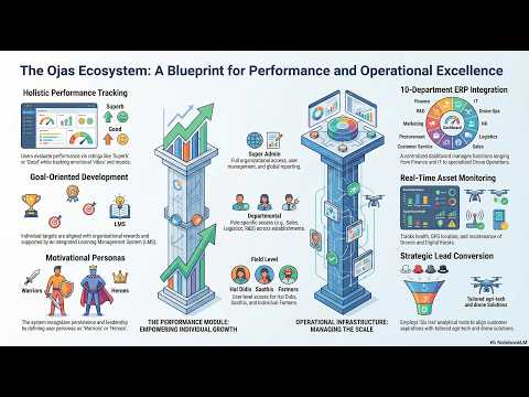
HAL ERP PLATFORM — BUSINESS INTELLIGENCE & OPERATIONS
ERP · PLATFORM
The HAL (Hub for Aerial Logistics) ERP is the central operating system for every franchise. Built as a cloud-hosted SaaS on a microservices architecture, it unifies fleet telemetry, crop intelligence, farmer bookings, revenue tracking, and government scheme compliance into a single dashboard. Every station's data feeds the network, enabling cross-station analytics and federated model improvement.
🛰
FLEET OPERATIONS CENTER
Live GPS tracking via GNSS telemetry streamed from ArduPilot/PX4 flight controllers over 4G modems onboard each drone. Job completion is auto-verified by geofence exit detection. Pilot scheduling uses an optimisation algorithm that minimises travel time across multiple farm bookings in a day.
Real-time GPS · Geofence logs · Dispatch optimise
🌐
DIGITAL TWIN FARM PLATFORM
Each enrolled farm gets a geo-referenced digital replica stored as GeoTIFF and vector shapefiles. Drone photogrammetry generates orthomosaic maps using Structure-from-Motion (SfM) algorithms. The twin is updated on every survey flight and linked to crop history, input records, and soil data — all accessible via farmer mobile app.
GeoTIFF · SfM ortho · Crop history · Mobile app
🏛
GOVERNMENT SCHEME INTEGRATION
API-level integration with PM-KISAN (farmer income support portal), FAME-II (EV subsidy), PM-KUSUM (solar pump scheme), Fasal Bima Yojana (crop insurance enrolment + drone-based loss assessment), KCC (Kisan Credit Card), and e-NAM (National Agriculture Market) for digital mandi price discovery and lot listing.
PM-KISAN · FAME-II · PM-KUSUM · e-NAM · KCC · FBY
📊
REVENUE & ANALYTICS ENGINE
Real-time revenue tracking across all 6 service verticals — drone spraying (per-acre), training (per-student), sales (margin-based), repair (job cost), EV/solar (margin), and government contracts. Automated GST-compliant invoicing. Cross-station benchmarking shows each franchisee where they stand in the network percentile.
The intelligence layer combines drone-captured multispectral imagery, satellite data, IoT sensor streams, and historical crop records into actionable advisory. NDVI (Normalized Difference Vegetation Index) is calculated from the NIR and Red bands: NDVI = (NIR − Red) / (NIR + Red). Values near +1 indicate dense healthy canopy; values near 0 or negative indicate bare soil or diseased/dead vegetation — enabling sub-field-level health mapping at centimetre resolution.
DRONE SURVEY
→
MULTISPECTRAL RAW
→
NDVI COMPUTE
→
+ SAT SENTINEL-2
→
AI YIELD MODEL
→
VRA PRESCRIPTION
🛰
SATELLITE + DRONE DATA FUSION
Sentinel-2 (ESA, free, 10m resolution, ~5-day revisit) provides frequent temporal coverage. Drone surveys add centimetre-resolution detail on key dates. A data fusion algorithm — using spatial super-resolution and temporal interpolation — merges both sources to create daily field-level health maps far more accurate than either source alone.
Sentinel-2 10m · Drone 0.5–2cm · Daily composites
🧠
AI YIELD PREDICTION MODEL
Regression and deep learning models trained on multi-year crop datasets. Input features include Growing Degree Days (GDD), NDVI time-series trajectory, soil organic carbon %, rainfall deviation from 10-year seasonal average, pest-pressure index from image classification, and variety-specific phenological stage. Outputs predicted yield per plot 6–8 weeks before harvest.
GDD · NDVI time-series · Soil OC · Pest index inputs
🗺
VARIABLE RATE APPLICATION (VRA)
The NDVI map is divided into a prescription grid — each cell (1m × 1m or 5m × 5m) specifies a different input rate based on the measured crop stress index. The drone flight controller reads this geo-referenced prescription file and dynamically adjusts pump speed (and therefore droplet size and volume) in real time as it crosses each cell. Reduces input waste by 20–35%.
Per-cell rate control · 20–35% input saving · RTK precision
🌿
FEDERATED LEARNING NETWORK
Each station's crop AI model improves from local field data without raw data leaving the station — a privacy-preserving machine learning approach called Federated Learning. Only model weight gradients (not raw images or farmer data) are sent to the central server for aggregation. This creates a continuously improving network model from across 430+ stations.
BLOCKCHAIN LAYER — DATA PROVENANCE · SMART CONTRACTS · TRACEABILITY
BLOCKCHAIN
Every field survey, soil test, spray job, and government scheme transaction generates data that needs to be trusted — by banks issuing crop loans, insurers assessing crop loss, mandis validating produce origin, and government bodies disbursing subsidies. Meghdev's blockchain layer creates an immutable audit trail using a permissioned distributed ledger (compatible with Hyperledger Fabric or a private EVM chain), where each data record is cryptographically hashed and chained to the previous one — making retroactive falsification mathematically impossible.
GENESIS BLOCK
0x00000...a1f3
Farmer KYC Land record GPS boundary
SOIL BLOCK
0x4f2a1...c8d7
NPK values pH / EC Date stamped
SURVEY BLOCK
0x9b3e8...12aa
NDVI map hash Flight log CID Pilot ID
SPRAY BLOCK
0xd1f7c...4509
VRA prescription Volume sprayed Input lot no.
SUBSIDY BLOCK
0x2c4b9...f830
PM-KISAN txn Smart contract Auto-disbursed
HARVEST BLOCK
0x7e9a3...01bc
Yield verified e-NAM lot ID Produce origin
🔗
IMMUTABLE CROP DATA RECORDS
Every drone survey output, soil test result, and input application is hashed using SHA-256 and stored on-chain. The hash of the raw data file (stored on IPFS or a private CDN) is recorded, ensuring that even if a central server is compromised, the integrity of any record can be independently verified against its on-chain hash — creating court-admissible agricultural data.
SHA-256 hash · IPFS CID · Immutable audit trail
📜
SMART CONTRACT SUBSIDY DISBURSEMENT
Government subsidy triggers (PM-KISAN instalments, NABARD agri-infra credit) are encoded as smart contracts that auto-execute when verifiable conditions are met — e.g., drone survey confirms crop exists, soil test confirms planting was done, NDVI confirms healthy stand. Eliminates manual claim processing and significantly reduces fraud risk.
EVM-compatible · Oracle-verified · Auto-execute
🌾
SUPPLY CHAIN TRACEABILITY
Produce that goes through the e-NAM marketplace carries a tokenised origin certificate traced back through the entire chain — seed lot, input applications, soil test, irrigation records, and drone survey — to the specific GPS-bounded farm plot. Agri-exporters and APMC mandis can scan a QR code to verify the complete production chain, unlocking premium pricing for traceable produce.
Origin token · QR verifiable · APMC + export ready
🪙
FARMER LOYALTY TOKENISATION
Enrolled farmers earn non-transferable digital tokens for each drone service used, soil test conducted, and digital advisory session completed. Tokens can be redeemed for discounts on future services, agri-input purchases, or equipment rental. This creates a measurable on-chain engagement record, which banks and NBFCs can use as a proxy creditworthiness indicator for agri loans.
Soulbound tokens · Credit proxy · Service redemption
L7
DEEP COMPUTATION — EDGE AI · GPU INFERENCE · DISTRIBUTED PROCESSING
DEEP COMPUTE
Processing multispectral imagery, running satellite fusion algorithms, and serving real-time AI yield predictions for hundreds of concurrent farm plots requires significant compute — distributed between edge nodes at each station and a central GPU cluster in the cloud. The edge-first design means latency-sensitive operations (NDVI computation from a fresh drone survey, spray-window weather analysis) happen within the station itself, while heavy model training runs on GPU servers.
🖥
EDGE AI NODE (PER STATION)
Each Drone Station runs an embedded AI inference node — typically an NVIDIA Jetson AGX Orin or equivalent ARM-based SoC with a dedicated GPU/NPU. This processes raw multispectral images into NDVI maps locally, runs pest/disease classification models on survey imagery, and serves the Digital Twin farm platform without requiring cloud round-trips. Consumes <60W — runs on solar power.
Jetson AGX Orin · INT8 inference · <60W · Solar-powered
ON-DEVICE NDVI
PEST CLASSIFIER
OFFLINE CAPABLE
☁
CENTRAL GPU CLUSTER
A cloud-hosted GPU cluster (A100 or H100 class) runs the heavy workloads: federated learning model aggregation from all 430+ stations, satellite imagery batch processing, seasonal crop calendar generation, and large language model (LLM) inference for the farmer advisory chatbot. Jobs are queued and prioritised by a distributed task scheduler.
Structure-from-Motion is the core algorithm turning hundreds of overlapping drone photos into orthomosaic maps. The drone flies a grid pattern with 75–85% lateral overlap. SfM identifies matching keypoints across images using SIFT/ORB descriptors, reconstructs a 3D point cloud, and renders a georeferenced orthoimage. Output is a GeoTIFF accurate to ground sampling distance (0.5–2 cm/px for survey drones).
SIFT/ORB matching · Dense point cloud · GeoTIFF output
🔬
COMPUTER VISION PIPELINE
A multi-stage CV pipeline processes each survey: (1) raw image ingestion, (2) radiometric calibration using reference panel, (3) SfM orthoprocessing, (4) band index calculation (NDVI, NDRE, GNDVI), (5) anomaly detection via CNN-based classifier trained on 50,000+ labelled crop disease images, (6) zone segmentation, (7) prescription map generation. Full pipeline completes in 8–18 minutes on edge hardware.
CNN classifier · 50k+ labelled dataset · 8–18 min pipeline
Beyond automated image analysis, Meghdev integrates large language models (LLMs) as a conversational intelligence layer accessible to farmers via WhatsApp, the Agri Marketplace App, or a voice IVR system in regional languages. Prompt engineering — the craft of designing structured instructions that reliably steer an LLM's output — is what makes generic AI usable as a precise, safe, and grounded crop advisory tool.
🤖
FARMER AI ADVISORY CHATBOT
An LLM fine-tuned on Indian agricultural extension data, crop science literature, ICAR advisory bulletins, and 3 years of station-level field records. Farmers describe symptoms in their own words (text or voice) and receive structured, actionable advice in Hindi, Marathi, Telugu, Kannada, and other regional languages. The system also proactively pushes advisories when a farm's NDVI drops below threshold.
Multi-language · Voice-to-text · ICAR knowledge base
WHATSAPP NATIVE
VOICE IVR
8+ LANGUAGES
⚙
SYSTEM PROMPT ARCHITECTURE
Every farmer query is wrapped in a structured system prompt that injects the farmer's Digital Twin context — current NDVI values, soil test results, crop variety, growth stage, recent weather, and input history — before reaching the LLM. This grounds the model's response in real field data rather than generic advice, dramatically reducing hallucination risk for safety-critical agricultural recommendations.
SYSTEM: You are an expert agri-advisory assistant for Meghdev Drone Station.
Respond ONLY in {farmer_language}. Base your advice exclusively on the field data provided.
Do NOT recommend any inputs not listed in {approved_inputs_list}.
If unsure, escalate to human agronomist — never guess on pesticide dosages.
FIELD CONTEXT:
• Farmer: {farmer_name} | Plot: {gps_boundary} | Crop: {crop_variety}
• Growth stage: {phenological_stage} | Days to harvest: {dtm}
• Last NDVI: {ndvi_value} ({ndvi_status}) | Soil pH: {ph} | N-P-K: {npk}
• Last 7-day rainfall: {rainfall_mm}mm | Wind forecast: {wind_speed} km/h
QUERY:{farmer_query_translated_to_english}
🔍
RAG — RETRIEVAL-AUGMENTED GENERATION
For complex crop disease queries, the LLM retrieves relevant passages from a vector database of ICAR bulletins, KVK advisories, and peer-reviewed agronomy literature using semantic similarity search (embeddings). Retrieved chunks are injected into the prompt as grounding context, enabling the model to cite specific recommendations from authoritative sources rather than relying on parametric memory alone.
Vector DB · Semantic search · Source-cited outputs
🌍
VOICE-TO-TEXT + MULTILINGUAL PIPELINE
A speech recognition model (ASR) fine-tuned on Indian agricultural vocabulary — covering crop names, pest names, and agronomic terms in 8+ regional languages — converts voice messages into text. This text is translated to English for LLM processing, the response is generated, then translated back to the farmer's language and optionally converted back to speech via a TTS (text-to-speech) engine.
Fine-tuned ASR · Hindi/Marathi/Telugu/Kannada · TTS output
L0
ENERGY INFRASTRUCTURE — SOLAR · LiFePO4 · DC FAST CHARGING
ENERGY
The entire station runs on a hybrid solar + grid architecture. The solar array generates primary power during daylight, excess is stored in a LiFePO4 battery bank (chosen for safety and cycle life over LiPo), and the grid provides backup during cloudy periods or nighttime. The PM-KUSUM scheme allows surplus solar generation to be sold back to the DISCOM via net metering, turning the energy system into an additional revenue stream.
SYSTEM
SPEC (DRONE STATION)
SPEC (FAME HUB)
NOTES
Solar PV Array
10 kW peak (mono PERC)
25+ kW peak
PM-KUSUM eligible · net metering
Battery Bank
LiFePO4 20 kWh
LiFePO4 50 kWh
4000+ cycle life · no thermal runaway
Inverter
String inverter, 48V DC bus
Central inverter
MPPT charge controller
Autonomy (no sun/grid)
8–12 hours
12–18 hours
Covers full operational day
EV Charging (2/3 wheeler)
Level 2 AC 7.2 kW
DC fast 30 kW
FAME-II compliant
EV Charging (4 wheeler)
DC fast 30 kW CCS2
DC fast 120–150 kW
CCS2 + CHAdeMO protocols
Drone Charging Draw
~6 × 1.5 kW = 9 kW
~12 × 1.5 kW = 18 kW
Managed by BMS scheduling
Grid Connection
3-phase 15 kVA
3-phase 40 kVA
Net metering + surplus sale
—
DGCA SIMULATION TRAINING INFRASTRUCTURE
TRAINING
DGCA's Remote Pilot Certificate (RPC) programme requires candidates to complete a minimum number of simulation hours before physical flight training. Each simulation station combines a physical transmitter/controller connected to high-fidelity UAV simulation software, with visual display of flight dynamics, weather effects, emergency scenarios (motor failure, GPS loss, battery-low RTH), and terrain following.
🎮
UAV SIMULATION SOFTWARE
Flight simulators replicating specific drone models' flight characteristics — DJI Agras series and ArduPilot-based platforms. Simulation scenarios include: normal spraying missions, motor failure at altitude, GPS spoofing, obstacle avoidance failure, and emergency landing. Students must achieve 95%+ completion rate across all scenarios before advancing to physical flight.
DGCA-approved · Category 1–3 · 4–6 stations per facility
🏆
DGCA CERTIFICATION PATHWAY
Category 1 (micro UAV <250g) through Category 3 (large >25kg) certifications. The RPC exam covers airspace rules, meteorology, drone systems, emergency procedures, and human factors. Meghdev stations are authorised Registered Training Organisations (RTOs) — meaning certificates issued are valid for DGCA-licenced commercial operations.
Our technology team is available for site assessment, connectivity planning, AI integration consultations, and full-stack architecture walkthroughs for prospective franchise partners.
1–2 PER DISTRICT · FULL DRONE PORT · FOUR TECHNOLOGY PILLARS
India's first container-based district-level technology hub — DGCA-certified drone operations, FAME-II EV sales & charging, solar installation, and comprehensive training. 1–2 hubs per district based on area and population — across all 753 districts of India.
753
Target districts
28
States covered
15+
Jobs per hub
3yr
Break-even target
◆ DGCA-CERTIFIED DRONE OPS◆ EV CHARGING 6 SIMULTANEOUS BAYS◆ SOLAR 10–15KW + BATTERY BACKUP◆ 25 KM DELIVERY RANGE · 5 KG PAYLOAD◆ FAME-II EV SUBSIDY ELIGIBLE◆ CONTAINER HUB — 6–10 WEEKS SETUP◆ PM-KUSUM SOLAR SUBSIDY FACILITATION◆ DGCA-CERTIFIED DRONE OPS◆ EV CHARGING 6 SIMULTANEOUS BAYS◆ SOLAR 10–15KW + BATTERY BACKUP◆ 25 KM DELIVERY RANGE · 5 KG PAYLOAD◆ FAME-II EV SUBSIDY ELIGIBLE◆ CONTAINER HUB — 6–10 WEEKS SETUP◆ PM-KUSUM SOLAR SUBSIDY FACILITATION
// ABOUT FAME HUB
India's first container-based district technology hub.
FAME Hub — Farming Aerospace Mobility Energy — is a modular 1-acre technology infrastructure deployed across India's 753 districts using shipping containers as fully equipped operational units.
Each hub is solar-powered, DGCA-UTM compliant, EV-charging ready, and fully operational within 6–10 weeks of commissioning. Each district gets 1–2 FAME Hub franchisee partners — owning the district-level technology access point for F, A, M and E sectors.
1–2 FAME Hubs serve each district — the only sources for DGCA-certified drone services, EV sales, EV fast-charging, solar installation, agri-tech, and logistics delivery. Allocated by district area and population. Container-based means 40–60% lower capital than permanent construction.
F
FARMING
Drone agri-ops, NDVI, precision spraying, land records
A
AEROSPACE
Delivery drones, photography, inspection, survey
M
MOBILITY
EV scooter sales, service, fast-charging stations
E
ENERGY
Solar 1–100 kW, PM-KUSUM, net-metering, AMC
MISSION BRIEF
"Make every district self-sufficient in agriculture technology, clean mobility, and energy independence — through a single hub that anyone can access."
The FAME Hub model brings 4 critical technology sectors to district-level users who currently lack access. The container format eliminates construction risk, solar powers the hub at near-zero operating cost, and the franchise model enables local ownership rather than absentee corporate penetration.
FAME drones cover 10–15 acres per hour with centimetre-level RTK GPS and variable-rate spraying. Per-acre pricing makes drone agri accessible without ownership.
15 ac/hr40% less chemicals±2cm GPS
// Use cases
Precision pesticide & fertilizer spraying
NDVI crop health and stress mapping
Aerial seeding for paddy and cover crops
Farm boundary survey & land record digitisation
Yield estimation 4–6 weeks before harvest
SECTOR 02 · A — AEROSPACE
Healthcare & Logistics Delivery
In monsoon season, in hilly terrain — roads stop but FAME drones don't. Emergency delivery of medicines, blood, vaccines to PHCs unreachable by road.
25 km range5 kg payload30 min avg
// Use cases
Emergency medicine delivery to remote PHCs
Blood & vaccine cold-chain last mile
E-commerce delivery to villages without roads
Emergency supply drops during flood or disaster
Bank & government document transfer
SECTOR 03 · A — AEROSPACE
Photography & Aerial Media
Weddings, real estate, tourism, agri-insurance — served by DGCA-certified photography pilots with 4K and 6K aerial platforms at competitive day rates.
4K / 6K video45MP imaging45 min flight
// Use cases
Wedding & cultural event aerial coverage
Real estate photography and virtual tours
Tourism & heritage site documentation
Agricultural insurance crop damage surveys
Film, advertisement, and news production
SECTOR 04 · A — AEROSPACE
Industrial Inspection
Power line thermal inspection, solar farm audits, construction surveys — zero human risk, 10× faster, 60% cost reduction versus manual inspection.
Zero human risk10× faster60% cost saving
// Use cases
High-voltage power line thermal survey
Solar farm panel performance audit
Construction site progress & volumetrics
Cell tower & telecom infrastructure check
Gas pipeline & industrial plant survey
SECTOR 05 · A — AEROSPACE
Security & Disaster Response
Flood area mapping, thermal search and rescue flights, crowd management — operating under MoU with district collectors and SDRF teams.
Modular shipping containers convert into fully operational service units — relocatable, scalable, 40–60% cheaper than permanent construction. Solar-powered from Day 1.
20ft container · 6 EV charging bays · Fleet storage
Zone E
Solar canopy + admin
10–15 kW solar · Office · Power backup · LiFePO4 bank
Primary power10–15 kW solar + grid
Battery backupLiFePO4 20kWh · 8–12 hr
EV charging bays6 simultaneous AC+DC
Drone launch pads2 simultaneous
ADS-B beaconV2 — DGCA UTM ready
Weather stationWMO-compliant
Connectivity4G / 5G / Satellite
SecurityCCTV 8-cam 4K
Factor
FAME Container Hub
Permanent Structure
Setup time
6–10 weeks
6–12 months
Capital cost
₹25–50 Lakh
₹60L–1.5 Crore
Monthly power cost
~Zero (solar)
₹15K–25K/month
Relocatable
Yes — containers move
No — permanent
Land ownership needed
Lease sufficient
Usually ownership
📦
CONTAINER-BASED — RELOCATABLE & SCALABLE
Standard 20-foot shipping containers convert into operational service units. Modular and standardised — add a container to scale any division. Relocate if your market dynamics change.
☀️
SOLAR-FIRST — NEAR-ZERO OPERATING COST
The 10–15 kW rooftop solar powers drone charging, EV charging bays, and all hub operations at near-zero marginal cost. Competitors paying grid tariff spend ₹15,000–25,000/month more — every month, for decades.
⚡
EV CHARGING — 6 SIMULTANEOUS BAYS
AC slow charge and DC fast-charge bays for two-wheelers and three-wheelers. Solar-powered charging means revenue from every kWh with zero input cost. WhatsApp booking integration and app management included.
📡
ADS-B V2 & GEOFENCING — FULL DGCA COMPLIANCE
ADS-B V2 beacon provides real-time airspace awareness integrated with DGCA's DigitalSky UTM. GPS geofencing with AES-256 encrypted RTK base station. Every flight is UTM-compliant from launch.
Drone dispatch booking, EV charging bay management, inventory tracking, customer billing, service tickets, and district-level analytics — all in one app with WhatsApp Business integration.
DGCA-certified drones. Performance EVs. Solar systems.
Category 01 · Agricultural spraying
Agri Spraying Drones
High-capacity platforms with multi-directional obstacle avoidance, centimetre-level RTK GPS, variable-rate application, and intelligent autonomous flight planning for precision farming.
Tank capacity10L / 20L / 40L / 70L
Coverage rate7–15 acres/hour
GPS accuracy±2cm (RTK)
Max wind10 m/s (heavy lift)
₹2.5L – ₹18L depending on tank capacity
✓ DGCA type-certified
Category 02 · Survey & mapping
Survey & Photography Drones
Professional-grade platforms for land surveying, orthomosaic mapping, real estate photography, construction monitoring, and high-resolution aerial documentation with LiDAR capability.
Camera12MP – 45MP / 4K–8K
Flight time28–45 minutes
Range8–20 km transmission
Speed54–82 km/h
₹50K – ₹15L based on sensor payload
✓ DGCA type-certified
Category 03 · Logistics & delivery
Logistics & Delivery Drones
Purpose-built for last-mile cargo delivery of medicines, agri inputs, and e-commerce packages to villages unreachable by conventional transport during monsoon or in hilly terrain.
PayloadUp to 5 kg
Delivery range25 km radius
Avg delivery~30 minutes
NavigationAutonomous waypoint
₹3L – ₹20L depending on payload and range
✓ DGCA type-certified
Category 04 · Industrial inspection
Industrial Inspection UAVs
Heavy-duty inspection platforms with thermal and RGB dual payload, optional LiDAR integration, and IP55 weather resistance for power line surveys and solar farm thermal audits.
Payload typeThermal + RGB dual
IP ratingIP55 weatherproof
Endurance35–55 minutes
Wind toleranceUp to 12 m/s
₹5L – ₹30L depending on payload configuration
✓ DGCA type-certified
Entry range · 1000W motor
Eco Shine 12/10
Gateway model — 1000W motor, front disc/rear drum braking, LED headlamp, digital colour speedometer. Designed for daily commuters and first-time EV buyers across rural and peri-urban India.
Motor1000W
Range65–75 km (lithium)
Battery60V 32AH lithium
Charge time3–4 hours
₹22,000 + ₹19,152 lithium = ₹41,152 all-in
✓ FAME-II EV subsidy eligible
Performance range · 1200W motor
Eco Zypp 12/12
Cargo-ready open-frame moped design with 1200W motor and 90–100 km lithium range. Rear carrier rack, disc/disc braking. Built specifically for delivery fleets and last-mile logistics.
Motor1200W
Range90–100 km (lithium)
Battery60V 40AH lithium
DesignOpen frame + rear rack
₹28,500 + ₹23,940 lithium = ₹52,440 all-in
✓ Fleet pricing for 5+ units
Flagship · 1200W motor
Rapid Shine 12/12 — Flagship
Flagship with retro-futuristic body styling, 1200W motor, disc/disc braking. Showroom centrepiece that draws walk-in customers — six colour options including white, gray, red, blue, green, black.
Motor1200W
Range90–100 km (lithium)
Colours6 options available
Battery warranty3 years (lithium)
₹35,500 + ₹23,940 lithium = ₹59,440 all-in
✓ FAME-II eligible · 3-yr battery warranty
Standard across all Ecocruze models
Standard Features — Full Range
Every Ecocruze model sold through FAME comes with the complete standard equipment package. These features are fitted as standard by the manufacturer on every vehicle.
Turnkey residential system — Tier-1 BIS-certified panels, string inverter, roof mounting, DC/AC wiring, and DISCOM net-metering registration. PM-KUSUM subsidy facilitation. Install to commission in 7–10 days.
Capacity1 kW – 10 kW
Monthly saving₹1,500–15,000
Payback period4–6 years
Panel warranty25 years
After 30% PM-KUSUM subsidy: ₹45,000 – ₹3,50,000
✓ PM-KUSUM subsidy facilitation
Agricultural solar
Solar Agri-Pump — 3 to 10 HP
Solar-powered irrigation pump eliminating diesel and grid electricity costs for farmers. PM-KUSUM Component-A eligible with state + central subsidy up to 60–90%. Off-grid or on-grid.
Pump capacity3 HP – 10 HP
Subsidy60–90% (PM-KUSUM A)
Payback2–3 years post-subsidy
Fuel saving₹40,000–1,20,000/year
Net cost post-subsidy: ₹18,000 – ₹80,000 depending on HP
✓ PM-KUSUM Component-A eligible
Commercial solar
Commercial Installation — 10 to 100 kW
Large-scale solar for businesses, cold storages, schools, hospitals, and industrial units. Accelerated depreciation (40% Year 1). Net-metering, open access, group-captive all supported.
Capacity10 kW – 100 kW
Gross ROI15–22% per annum
Tax benefit40% accelerated depn.
CO2 offset0.7 kg CO2/kWh
Custom project quote — contact your FAME hub
✓ Net-metering + open access
Service contract
Annual Maintenance Contract (AMC)
FAME AMC keeps your solar system at peak performance across its 25-year life. Quarterly engineer visits — panel cleaning, inverter health check, wiring inspection, performance optimisation. Remote monitoring included.
Service visits4 per year (quarterly)
Remote monitoringOnline dashboard 24/7
Response time24 hours priority
Panel cleaningEvery visit
From ₹3,500/year (1–3 kW) · ₹8,000/year (4–10 kW)
✓ Covers panels, inverter, wiring
EV Charging · AC Slow
AC Slow Charge Bay — 2–3 kW
Ideal for overnight and extended dwell-time charging at hub premises. Compatible with all two-wheeler and light three-wheeler EVs. Standard 5-pin socket with smart metering and app-based payment.
Power2–3 kW AC
Charge time4–6 hours (full)
CompatibilityAll 2W & 3W EVs
PaymentApp + UPI + QR
₹2–3 / kWh charged (solar-cost advantage)
✓ FAME-II EV compatible
EV Charging · DC Fast
DC Fast Charge Bay — 15–25 kW
Rapid charging for commercial delivery fleets and premium EV models. Charges compatible vehicles to 80% in 30–45 minutes. CCS2, CHAdeMO, and GB/T connectors. Revenue-optimised for fleet operators.
Power15–25 kW DC
Charge time30–45 min (80%)
ConnectorsCCS2 + CHAdeMO
MonitoringRemote OCPP 1.6
₹8–12 / kWh or ₹150–200 / session
✓ Fleet billing integration
EV Charging · Solar integrated
Solar EV Charging System
The FAME Hub's 10–15 kW solar array directly powers EV charging bays — making every unit of charge delivered virtually free in electricity cost. Structural advantage over grid-dependent competitors that compounds monthly.
Solar input10–15 kW rooftop
Battery bufferLiFePO4 20 kWh
Grid-cost saving₹15K–25K/month
Bays powered6 simultaneous
Solar + storage capex: ₹8–12 Lakh (part of hub investment)
✓ Near-zero operating cost
Hub management
EV Charging Management System
Complete software + hardware stack for EV charging bay management — booking via WhatsApp, real-time bay status dashboard, automated billing, revenue reporting, and remote diagnostics for all OCPP-compliant chargers.
BookingWhatsApp + App
BillingUPI + QR + prepaid
MonitoringReal-time dashboard
AnalyticsRevenue + utilisation
Included in FAME Hub franchise package
✓ Included with FAME Hub tier
// HOW IT WORKS
Simple journeys for customers & partners.
1
Step 01
Call or WhatsApp your hub
Contact your FAME Hub directly. Describe your field size, crop, and what you need — spray, mapping, or seeding. No app download required to start.
WhatsApp or call the hub
Available 7am–7pm
2
Step 02
Site visit & quotation
A FAME drone pilot visits your farm within 24 hours. Reviews field access, crop type, obstacle proximity, and prepares your pricing. Typically ₹400–600/acre for spraying.
Visit within 24 hours
₹400–600/acre spraying
3
Step 03
Drone spraying mission
Certified DGCA pilot conducts the spraying using precision RTK GPS drone. Coverage rate 10–15 acres per hour. Digital mission report and spray log provided after completion.
10–15 acres per hour
Digital spray report
4
Step 04
Payment & next booking
Pay by cash, UPI, or account transfer after service delivery. Seasonal subscription plans available — pre-pay for 10+ spray sessions and save 15–20% versus walk-in rate.
Pay after service delivery
Seasonal plans save 15–20%
1
Step 01
Visit the hub showroom
Walk in to the FAME Hub sales + display container. Three Ecocruze models on live display. A FAME sales executive explains FAME-II subsidy eligibility, range, and financing options.
3 live display models
FAME-II subsidy explained
2
Step 02
Test ride + configuration
Take a test ride on the hub's dedicated test loop. Choose your motor configuration, battery type (lithium or lead-acid), and colour. Lithium recommended for range and 3-year warranty.
Test ride on-site
Lithium recommended
3
Step 03
Purchase + FAME-II subsidy
FAME Hub handles your FAME-II subsidy paperwork — reducing final price by ₹10,000–15,000 for eligible models. Registration, insurance, and charger installation arranged same day.
FAME-II subsidy applied
Same-day registration
4
Step 04
Charging membership
Enrol in FAME EV Charging membership — use any of the 6 hub charging bays at preferential solar-powered rate of ₹1.5/kWh versus grid rate of ₹6–8/kWh. Save ₹800–1,500/month.
₹1.5/kWh vs ₹6–8 grid
Save ₹800–1,500/month
1
Step 01
Free site assessment
FAME solar technician visits your site within 48 hours — measures roof area, orientation, existing electrical load, and DISCOM tariff rate. Provides a detailed ROI projection at zero cost.
Free visit within 48 hrs
Full ROI projection
2
Step 02
Subsidy & financing
FAME facilitates your PM-KUSUM subsidy application (30% residential, 60–90% agri pump). Bank loan with Mudra-linked financing at 7–9% interest rate. Net cost often below ₹1 lakh for 3 kW systems.
30% PM-KUSUM subsidy
Bank loan facilitation
3
Step 03
7–10 day installation
Certified FAME technicians install Tier-1 panels, string inverter, mounting structure, and complete all electrical work within 7–10 working days from subsidy sanction. DISCOM net-metering registration included.
7–10 working days
Net-metering included
4
AMC
AMC — maintained for life
Annual Maintenance Contract covers 4 service visits per year, remote monitoring dashboard, quarterly panel cleaning, inverter health checks, and 24-hour priority breakdown response.
4 service visits/year
From ₹3,500/year
1
Step 01
Submit expression of interest
Fill the FAME Hub application with your district, land availability, and investment capacity. Our team reviews all applications within 3–5 business days and confirms district availability.
3–5 business day review
One district per applicant
2
Step 02
Market assessment call
District manager confirms slot availability and discusses the right tier for your background. We verify financial capacity, land suitability, and local demand potential in a 30-minute video call.
30-minute video call
Personalised investment plan
3
Step 03
Hub setup in 6–10 weeks
Franchise agreement signed. Containers ordered and delivered. FAME technical team coordinates installation, branding, infrastructure commissioning — solar, ADS-B, EV charging bays, and ops system.
Containers delivered to site
Full setup support
4
Step 04
Launch with FAME backing
Grand opening with press outreach, digital campaign, WhatsApp broadcast to 5,000+ district contacts, and first 50 customer enquiries routed directly to your hub from FAME head office.
Press & social media launch
First 50 leads from FAME HQ
// APPLY NOW
Apply for a FAME Hub
One FAME Hub per district. Fill the application to check district availability and begin your partnership journey.
FAME HUB APPLICATION
PREMIUM TECHNOLOGY HUB · DISTRICT FRANCHISE
REF:
✓
Application Submitted!
Reference: FAME-2025-
Thank you for applying to become a FAME Hub partner. Our district team will review your application and contact you within 3–5 business days.
FAME Hub — FARMING · AEROSPACE · MOBILITY · ENERGY
All drone operations by DGCA-certified pilots. EV products FAME-II compliant. Solar by trained technicians. All partnerships subject to terms.
Meghdev delivers end-to-end farming intelligence — from soil testing to crop financing — with a Digital Twin of every farm powered by drone imagery, AI advisory, and precision agri tools. Every enrolled farm gets a real-time digital replica with geo-referenced plots, crop history, and predictive AI analytics.
12
AGRI SERVICES
360°
FARM COVERAGE
AI+IoT
TECHNOLOGY
₹3Cr+
AGRI POTENTIAL
🌿
AGRI · 01
CROP HEALTH MONITORING
Multispectral drone surveys, NDVI analysis, pest & disease early detection, canopy mapping, and growth stage monitoring across all crop types and farm sizes.
₹200–500 / acre / survey
🧠
AGRI · 02
AI CROP ADVISORY
AI-driven crop advisory based on real-time field data, weather, soil health, and crop stage. Personalised recommendations per plot via mobile app — available in local language.
Subscription-based · per farm
📦
AGRI · 03
CROP MARKETING
Digital marketplace integration, mandi price advisory, FPO linkage, e-NAM portal support, and direct buyer connections — helping farmers get better prices for produce.
Commission-based
🌾
AGRI · 04
AGRI INPUT SALES
Authorized dealership of certified seeds, fertilizers, pesticides, bio-inputs. Direct farmer supply with advisory support. PM-KISAN credit facilitation for input purchases.
15–25% margin
🚜
AGRI · 05
EQUIPMENT RENTAL
Custom hiring center for tractors, harvesters, transplanters, rotavators, and agri drones. Per-hour/acre rental through digital booking platform with GPS tracking.
₹500–5,000 / hour
👨🌾
AGRI · 06
MANPOWER BOOKING
Digital platform for agri labour booking — skilled & unskilled. Seasonal farm workers, tractor drivers, drone pilots, and field technicians on demand via mobile app.
Platform fee model
🧪
AGRI · 07
AGRI PATHLAB / SOIL TESTING
On-site and lab-based soil health card, water quality testing, tissue analysis, micro-nutrient testing. Drone-enabled field sampling for large farms. NABL-aspirant standards.
₹200–800 / test
💧
AGRI · 08
IRRIGATION AUTOMATION
IoT-based drip/sprinkler automation, soil moisture sensors, remote scheduling via app, and PM-KUSUM solar pump integration. Reduces water usage by 30–50%.
₹40,000–2L / install
🏭
AGRI · 09
STORAGE & TRANSPORTATION
Cold storage booking, warehouse linkage, FPO aggregation, drone-monitored storage, and last-mile farm-to-market transport coordination through our logistics network.
Commission + rental
💰
AGRI · 10
CROP FINANCING & INSURANCE
KCC facilitation, PM Fasal Bima Yojana enrollment, crop loss assessment by drone, input credit linkage, and NBFC/bank partnerships for agri loans at competitive rates.
Commission-based
🛰️
AGRI · 11
ADVANCED CROP INTELLIGENCE
Satellite + drone data fusion, AI yield prediction, crop calendar automation, precision variable rate application, and hyperlocal weather integration for every farm.
SaaS + field service
FLAGSHIP
🌐
AGRI · 12
DIGITAL TWIN OF FARM
Every enrolled farm gets a real-time digital replica — geo-referenced plots, crop history, input records, yield data, and predictive AI analytics accessible via mobile app 24/7.
Annual subscription
▸ TECHNOLOGY STACK POWERING EVERY FARM
ERP
BUSINESS INTEL
AI
CROP ADVISORY
IoT
IRRIGATION + SENSORS
SAT
SATELLITE IMAGERY
UAV
DRONE INTELLIGENCE
Bring Crop Intelligence to Your District
Every Meghdev franchise partner gets full access to the 12-stream agri platform — turning every station into a complete farm services hub.
// BLOCK / TEHSIL LEVEL FRANCHISE · AREA TERRITORY
VAIGO
CENTER · BLOCK/TEHSIL DRONE & TECH HUB
Vaigo Center is Ojas Aerospace's block/tehsil-level franchise. Designed for semi-urban and rural block headquarters, it brings together drone demos, EV solutions, agri services, tech training, and digital services under a single professional retail setup. Space requirement ranges from 500 sq.ft to up to 1 acre depending on services offered.
₹15–30L
INVESTMENT RANGE
18–24 Months
ROI TIMELINE
500 SQ.FT – 1 ACRE
SPACE REQUIRED
₹80L+
YEAR 1 REVENUE POTENTIAL
▸ SIX CORE SERVICE DIVISIONS
🏪
DRONE SHOWROOM
› Consumer & agri drone display
› Live flight demonstration area
› Accessories & spare parts
› Trade-in program
⚡
EV & MOBILITY HUB
› FAME-II EV scooter sales
› EV charging point (2-bay)
› EV service & diagnostics
› Subsidy facilitation
🌿
AGRI SERVICES DESK
› Crop monitoring bookings
› Soil testing & agri pathlab
› Input sales & advisory
› Crop finance facilitation
☀️
SOLAR SOLUTIONS
› Residential solar (1–10 kW)
› PM-KUSUM facilitation
› Rooftop survey by drone
› Energy consulting
💡
TECH TRAINING
› Drone pilot foundation course
› AI & robotics workshops
› Digital literacy programs
› Youth & women upskilling
📱
DIGITAL SERVICES
› HAL ERP access & dashboard
› Government scheme enrollment
› Online booking platform
› Insurance & financing desk
₹80L+
YEAR 1 REVENUE
6+
REVENUE STREAMS
5,000+
CATCHMENT FARMERS
BLOCK
TERRITORY RIGHTS
Open a VAIGO Center in Your Block
Be the first Meghdev partner at Block/Tehsil level — secure your territory and tap into 5,000+ catchment farmers.
// HAL CENTER · VILLAGE TOUCH POINT · OJAS AEROSPACE
India's Last-Mile Digital Kiosk Command Center
HAL Center is Ojas Aerospace's village-level anchor — a single Digital Smart Kiosk that bridges drones, agri-AI, government services, EV mobility, and rural commerce. The final touch point in India's drone network, placed at Gram Panchayat level.
HAL Center is a unique initiative by Ojas Aerospace that promotes technological innovation at the grassroots level to realize the vision of "Digital Bharat, Developed Bharat." It is a multi-utility digital innovation and experience hub designed to serve farmers, retailers, logistics providers, self-employed individuals, and government institutions.
Through a single Digital Smart Kiosk, HAL Center facilitates seamless access to drone operations, agri-AI advisory, government schemes, EV solutions, and rural commerce — making it the final, most critical touch point in India's drone network ecosystem.
COVERAGE AREA
1 Gram Panchayat territory · 1,000–5,000 population radius
SPACE REQUIRED
300–800 sq.ft · Indoor or semi-outdoor facility
STAFF NEEDED
1–3 trained operators · DGCA pilot optional
YEAR 1 REVENUE
₹18L–40L potential · 6+ active revenue streams
// SERVICES & FACILITIES
Everything the Village Needs — Under One Roof
🚁
PILLAR · 01
DRONE OPERATIONS HUB
Complete UAV services — sales, rental, training, repair, and live mission dispatch from the kiosk interface. DGCA-certified pilot on call for agricultural and logistics operations.
▶ Drone sales (agri, photo, industrial)
▶ Daily/weekly/seasonal rental
▶ DGCA pilot training & certification
▶ Repair, maintenance & spares
▶ Spray booking via digital kiosk
REVENUE: ₹800–4,500 / drone / day
🌾
PILLAR · 02
AGRI-AI INTELLIGENCE
AI-powered crop advisory, multispectral drone surveys, NDVI mapping, soil testing, and precision input recommendations. Every farm gets a real-time Digital Twin on the kiosk dashboard.
▶ Crop health monitoring (NDVI/NDRE)
▶ Soil & water testing on-site
▶ AI crop advisory (local language)
▶ Precision spray scheduling
▶ Farm Digital Twin dashboard
REVENUE: ₹200–500 / acre / survey
🏛️
PILLAR · 03
GOVT-TO-CITIZEN SERVICES
Digital access point for all government schemes, documentation, and rural services — eliminating the need for villagers to travel to district centers for basic government interactions.
▶ PM-KISAN, PMFBY enrollment
▶ Aadhaar, PAN, ration card services
▶ Insurance & banking facilitation
▶ NABARD / MUDRA loan assist
▶ Digital payments & UPI desk
REVENUE: Commission per transaction
⚡
PILLAR · 04
EV & CLEAN ENERGY
Village-level EV charging point, e-scooter sales, solar rooftop facilitation, and drone battery swapping station — powering the clean energy transition at the grassroots level.
▶ EV two-wheeler sales & demo
▶ EV charging bay (2-kW fast charge)
▶ Drone battery swap station
▶ Solar rooftop via PM-KUSUM
▶ Energy advisory & survey
REVENUE: ₹20–80 / charge session
🛒
PILLAR · 05
AGRI-COMMERCE & INPUTS
Authorized agri-input dealership, produce aggregation, mandi price advisory, crop marketing linkage, and FPO support — connecting the village to the larger agri supply chain.
▶ Seeds, fertilizer, pesticide sales
▶ Produce aggregation & grading
▶ Mandi price advisory & e-NAM
▶ FPO linkage & crop finance
▶ Equipment rental booking
REVENUE: 15–25% margin on inputs
🎓
PILLAR · 06
RURAL SKILLING CENTER
Upskilling for rural youth, women SHGs, and ITI graduates — drone pilot certification, AI & robotics basics, digital literacy, and vocational tech programs conducted at the kiosk facility.
HAL CENTER · VILLAGE-LEVEL FRANCHISE · OJAS AEROSPACE PVT. LTD.
◀ BACK TO HOME
Partner Types & Eligibility
// WHO CAN BECOME A PARTNER
Partner Types & Eligibility
Meghdev welcomes a diverse range of franchise partners — from individual entrepreneurs to institutions. Each partner type unlocks specific tiers and territory models. No prior tech background required — full training and support provided.
👤
TYPE · 01
INDIVIDUAL ENTREPRENEUR
Salaried professionals, business owners, or ambitious individuals looking to invest in a future-ready franchise. No prior tech background required — full training provided.
✓Age 21+ with entrepreneurial drive
✓Min. investment capacity ₹5L+
✓Land or rental space available
✓Good local community network
ELIGIBLE: HAL CENTER / VAIGO CENTER / DRONE STATION
🧑🌾
TYPE · 02
AGRI-ENTREPRENEUR / FPO
Progressive farmers, FPOs, or agri-input dealers who want to add drone services, smart farming tech, and agri advisory to their existing operations.
✓FPO / agri dealer / progressive farmer
✓Farmland or agri premises available
✓Existing farmer customer network
✓NABARD / KCC credit access
ELIGIBLE: HAL CENTER / VAIGO CENTER / DRONE STATION
🎓
TYPE · 03
RURAL TECH YOUTH / SHG
Educated rural youth, women SHG leaders, Atal Tinkering Lab coordinators, or ITI graduates who want to build a scalable tech-led livelihood with drone training and services.
✓10th / 12th / ITI / diploma pass
✓Min. investment ₹5L (assisted loans)
✓PM-Mudra / PMEGP loan eligible
✓Community leadership ability
ELIGIBLE: HAL CENTER · OPERATOR PARTNER
🏪
TYPE · 04
EXISTING BUSINESS OWNER
Owners of agri-input shops, hardware stores, EV dealerships, irrigation companies, or solar businesses looking to add drone services to their existing portfolio.
✓Active registered business entity
✓GST registered, 2+ years ops
✓Existing premises / customer base
✓Upgrade to tech franchise
ELIGIBLE: HAL CENTER / VAIGO CENTER
🏢
TYPE · 05
CORPORATE / INSTITUTIONAL
NGOs, trusts, educational institutions, KVIC-affiliated bodies, state agri corporations, or companies wanting to establish drone infrastructure for their community or service area.
✓Registered entity (Pvt Ltd / Trust / NGO)
✓CSR / govt scheme funding eligible
✓Land / campus space available
✓Multi-tier deployment preferred
ELIGIBLE: DRONE STATION / FAME HUB / MULTI-UNIT
FLAGSHIP
🌟
TYPE · 06
FAME HUB DISTRICT INVESTOR
High-net-worth investors, real-estate developers, agri-corporate groups, or visionary entrepreneurs who want to establish the district's premier drone port, EV hub, and agri command center.
✓Investment capacity ₹45L–1 Crore
✓1 Acre+ land (own / lease) available
✓District-level business network
✓Only 1–2 slots per district
ELIGIBLE: FAME HUB · DISTRICT COMMAND CENTER
▸ FINANCING SUPPORT FOR ALL PARTNER TYPES
PM-MUDRA
Loan up to ₹10L for micro-entrepreneurs
PMEGP
Startup grant 15–35% for rural areas
NABARD
Agri-infra loans & rural schemes
KCC CREDIT
Kisan Credit Card agri equipment
BANK LOAN
Assisted documentation support
Ready to Join the Network?
No matter your background — individual, farmer, youth, or investor — there's a Meghdev tier built for you. Apply today and secure your territory.
Visit our Farm HQ Center or send us a message — our team is ready to guide you through partnership opportunities, drone station applications, and FAME HUB inquiries.
HEADQUARTERS — LIVE
OJAS AEROSPACE PRIVATE LIMITED
FARM HQ CENTER
📍
ADDRESS
F63-B, Radhey Mohan Drive Chhatarpur, New Delhi – 110074
Reviewed by founding team within 5 working days · Confidential
🚀
APPLICATION SENT!
We'll be in touch within 5 working days. Meanwhile, explore more of what we're building at Ojas Aerospace.
◀ BACK TO HOME
MEGHDEVDYNAMICS
// PHYSICAL INFRASTRUCTURE
Container-BasedDrone StationInfrastructure
India's first modular, rapidly-deployable drone operations platform built on ISO shipping containers — fully off-grid capable, DGCA-compliant, and field-proven across all terrain types.
4
STATION TYPES
40ft
ISO CONTAINERS
1AC
MIN LAND (FULL)
90
DAYS SETUP
// AERIAL VIEW — MEGHDEV DRONE STATION
SCALE: ~1 ACRE TOTAL2× 40FT + 1× 20FT ISO CONTAINERS● LIVE LAYOUT
CONTAINER SPECIFICATIONS
UNIT 01 · MAIN OPS
40FT ISO Container
Dimensions
12.19m × 2.44m × 2.89m
Floor Area
~29.7 sqm
Structure
Cor-ten steel, insulated
Zones
Reception · Charging · Sitting
Power Load
10–15 kW
UNIT 02 · TRAINING & REPAIR
40FT ISO Container
Dimensions
12.19m × 2.44m × 2.89m
Floor Area
~29.7 sqm
Structure
Cor-ten steel, insulated
Zones
Sim Lab · Workshop · Storage
Power Load
8–12 kW
UNIT 03 · CONTROL
20FT ISO Container
Dimensions
6.06m × 2.44m × 2.59m
Floor Area
~14.8 sqm
Structure
Cor-ten steel, insulated
Zones
ERP Control · Comms · CCTV
Power Load
3–5 kW
FACILITY MODULES
📡
ADS-B V2 BEACON
FAA/DGCA-compliant ADS-B transponder for full airspace awareness within 50km radius. Real-time UAV traffic coordination, collision avoidance, and flight tracking. Roof-mounted with 360° coverage.
⚡
6-BAY CHARGING SYSTEM
Simultaneous charging of 6 drones — LiPo 4S–12S, LiFePO4 packs. Smart BMS with individual cell monitoring, 240V AC + DC fast charge. Solar input compatible. Auto surge protection.
☀️
SOLAR POWER SYSTEM
10–100 kW rooftop solar array across container roofs. MPPT inverter, battery bank for 8h off-grid ops. Grid fallback. Powers all container units + charging bays + signage.
🌦️
WEATHER STATION
Automated Davis/Vaisala weather module measuring wind speed/direction, temperature, humidity, barometric pressure, rain, and UV. Data fed to ERP for real-time flight-ops advisory.
📹
CCTV & SECURITY
8-camera IP CCTV system with night vision, motion detection, and cloud NVR. Perimeter alarm, electronic gate lock, and real-time monitoring via mobile app for station operators.
🌐
CONNECTIVITY HUB
Dual-SIM 4G/5G router + StarLink-compatible satellite backup. Dedicated VLAN for drone control systems, ERP cloud sync, and customer Wi-Fi. Uptime target: 99.5%.
LAND & INFRASTRUCTURE REQUIREMENTS BY TIER
TIER 02
🏪
HAL CENTER
HAL CENTER — Hyperlocal Operations
Shop/kiosk format ideal for market locations, panchayat offices, or standalone plots. Minimum 1 container unit or equivalent built-up area. Focused on drone sales, rental, and repair with a Smart Kiosk.
MIN LAND
500 sqm
CONTAINERS
1× 40ft
SETUP TIME
30 days
INCLUDED INFRA
✓ 1× 40ft container unit✓ 2-bay drone charger✓ Digital Smart Kiosk✓ 2 kW solar backup✓ CCTV + alarm✗ Drone port pad
TIER 03
🏬
VAIGO CENTER
VAIGO CENTER — Block / Tehsil Hub
Mid-scale block/tehsil format. 2 container units or equivalent. Adds drone showroom, EV 2-bay charger, agri services desk, and solar installation sales capability for broader territory coverage.
MIN LAND
2,000 sqm
CONTAINERS
2× 40ft
SETUP TIME
45 days
INCLUDED INFRA
✓ 2× 40ft container units✓ 4-bay drone charger✓ EV 2-bay charger✓ 5 kW solar + battery✓ Training room (10-seat)✓ Showroom fitout
TIER 04
🚁
DRONE STATION
MEGHDEV DRONE STATION — Full Scale
Full 1-acre facility. 3 container units + dedicated drone port pad. All 5 service divisions operational. DGCA-compliant operations pad, ADS-B beacon, full solar, boundary fencing, and ERP system.
MIN LAND
1 Acre
CONTAINERS
2×40ft+1×20ft
SETUP TIME
60–75 days
INCLUDED INFRA
✓ Full 3-unit container stack✓ DGCA ops pad 30×30m✓ ADS-B V2 beacon✓ 20 kW solar system✓ 6-bay charger + weather sta.✓ Boundary fence + gate
TIER 05
⬡
FAME HUB
FAME HUB — District Flagship
1+ acre premium campus. 5+ containers. Drone Port + EV 6-bay charging station + 50–100 kW solar farm + agri intelligence center + sub-franchise management hub. Limited to 1–2 per district.
MIN LAND
1–2 Acres
CONTAINERS
5+ units
SETUP TIME
75–90 days
INCLUDED INFRA
✓ 5+ container campus✓ EV 6-bay fast chargers✓ 50–100 kW solar farm✓ Full drone port (2 pads)✓ Sub-franchise dashboard✓ FAME Ops App + ERP
DRONE PORT — OPERATIONS PAD
India's First Village-Level UAV Port
Each Meghdev Drone Station includes a dedicated 30m × 30m DGCA-compliant operations pad — geo-fenced, lit for day/night operations, and integrated with the ADS-B air traffic awareness system.
Pad Dimensions
30m × 30m (900 sqm)
Surface Type
Paver / Concrete Apron
Marking Standard
DGCA / ICAO H-Pad
ADS-B Beacon Range
50 km radius
Perimeter Lighting
LED · Day + Night Ops
Geo-Fence Tech
RTK GPS + Digital Zone
◆ PORT COMPLIANCE
All Meghdev Drone Ports are designed to meet DGCA UAS Rules 2021 requirements for drone operations infrastructure including geo-fencing, ATC communication readiness, and ground crew safety standards.
POWER & CONNECTIVITY SYSTEMS
☀ SOLAR POWER SYSTEM
HAL Center2–5 kW solar
VAIGO Center5–15 kW solar
Drone Station20–30 kW solar
FAME Hub50–100 kW solar farm
🌐 CONNECTIVITY STACK
📶
4G/5G DUAL-SIM ROUTER
Dual-SIM cellular router with automatic failover between carriers. Dedicated VLANs for drone systems, ERP, and public Wi-Fi. Typical bandwidth: 50–200 Mbps.
🛰️
SATELLITE BACKUP (STARLINK-READY)
Integrated satellite internet input port — StarLink and other VSAT compatible. Ensures cloud ERP connectivity in zero-cell-coverage rural zones.
📱
ERP CLOUD SYNC
All station data — drone fleet status, booking records, inventory, revenue — synced to Meghdev HAL ERP cloud every 60 seconds. Firebase-powered real-time dashboard.
CONNECTIVITY UPTIME TARGET
99.5% UPTIME TARGET · DUAL REDUNDANCY
SUPPLIER & PROCUREMENT PORTAL
⬡ MEGHDEV PROCUREMENT NETWORK
We are actively building a trusted supplier network for containers, solar systems, EV chargers, drone hardware, surveillance systems, and construction services across India. If your company can supply any of these, apply below.
ACTIVE PROCUREMENT CATEGORIES
ISO Shipping Containers (20ft / 40ft)
Modified / insulated / fitted — PAN India delivery
OPEN
Solar Panels, Inverters & MPPT
Residential to commercial scale — 2 kW to 100 kW
OPEN
EV Charging Equipment (AC/DC)
2W/3W/4W chargers, OCPP controllers, management systems
OPEN
Drone Charging Systems (LiPo/LiFePO4)
Multi-bay simultaneous chargers with BMS — OEM/ODM
Our procurement team reviews within 48 hrs · Shortlisted suppliers notified via email
✓
APPLICATION RECEIVED
REF: PROC-XXXXX
Your supplier application has been submitted. Our procurement team will review and contact you within 48 hours if shortlisted.
Ready to Build Your Station?
Apply for a franchise and our infrastructure team will guide you through site selection, land requirements, container delivery, and full setup in 60–90 days.
India's pioneering drone operations company — from the country's first drone-based vaccine delivery to 35,000+ acres of precision agricultural spraying — built by a team of aerospace engineers, agronomists, pilots, and rural entrepreneurs transforming India's skies.
Ojas Aerospace · Daybest Research · VAiGO · i369 UK
Madhubani, Bihar → Delhi → UK → Pan-India
Serial entrepreneur with 16+ years of business experience spanning publishing, aviation, research and now rural tech. UK-recognized entrepreneur and founder of i369 Innovation Ltd. Pioneered India's first drone vaccine delivery (2021). Architect of the VAiGO FAME Hub model across 831 priority districts.
in𝕏✉
CO
Chief Operating Officer
COO · OPERATIONS HEAD
Field Operations · Center Network · Logistics
Lucknow, UP (HQ)
Oversees day-to-day operations of 27 active centers across UP, coordinating 80+ certified pilots and field teams. Drives ground execution of FAME Hub rollout, SLA compliance, and inter-district logistics for Ojas's expanding drone spraying network.
in✉
CT
Chief Technology Officer
CTO · TECH ARCHITECTURE
Drone Systems · HAL ERP · Software R&D
Remote / Bengaluru
Leads design and development of the HAL ERP platform, VAiGO National Command dashboard, and in-house drone systems. Oversees full-stack technology including drone hardware design, embedded firmware, precision agriculture sensors, and enterprise SaaS deployments.
in𝕏✉
CF
Chief Financial Officer
CFO · FINANCE & STRATEGY
Finance · Investor Relations · Compliance
Delhi / Mumbai
Manages financial architecture for Daybest Research Pvt. Ltd. and i369 Innovation Limited (UK). Oversees DPR structuring for government and investor submissions, revenue model validation across the ₹8–19 Cr per-station FAME Hub network, and multi-entity compliance.
in✉
CS
Chief Strategy Officer
CSO · STRATEGIC GROWTH
Business Strategy · Govt Relations · Partnerships
New Delhi
Drives VAiGO's national expansion across 831 priority districts. Manages government scheme integration (SMAM, PMKSY, RKVY, FAME-II), builds strategic alliances with IFFCO, UPL, Syngenta and state agri departments, and coordinates district-level policy advocacy.
in✉
CM
Chief Marketing Officer
CMO · BRAND & GROWTH
MEGHDEV Brand · Digital · Franchise Outreach
Pan-India / Remote
Heads the MEGHDEV brand strategy, VAiGO network marketing, and franchise outreach across rural districts. Manages digital presence, farmer engagement campaigns, and partnership marketing with IFFCO, DroneAcharya, and Drone Destination ecosystems.
in𝕏✉
CR
Chief Research Officer
CRO · R&D LEAD
Aerospace R&D · Precision Agri · ICAR Liaison
Research Station, UP
Leads in-house R&D for drone propulsion, payload optimization, logistics drone design, and precision agriculture intelligence. Published research recognized by ICAR. Bridging academic aerospace science with commercial agri-drone operations at scale.
in✉
CL
Chief Logistics Officer
CLO · LOGISTICS & SUPPLY CHAIN
Drone Logistics · EV Mobility · Cold Chain
Field Command, North India
Manages end-to-end logistics infrastructure for Ojas's drone network — from chemical supply chain to drone-as-a-service delivery. Spearheads the logistics drone program and EV mobility integration under the FAME Hub container station model.
in✉
DIRECTORS & SENIOR LEADERSHIP
DO
Director of Operations
DIRECTOR · FIELD OPS
UP Center Network · Pilot Management
UP Operations HQ
Directly manages 27 active HAL/VAIGO centers across UP. Coordinates spraying schedules, pilot deployment, and farmer liaison across 18+ districts of Uttar Pradesh.
in✉
DT
Director of Technology
DIRECTOR · TECH
Hardware R&D · Drone Design · Firmware
R&D Lab, India
Leads in-house drone design and development — currently delivering capabilities for logistics drones, spraying systems, and surveillance platforms. Partner with Flying Wedge, ePlane Co., and IoTech ecosystems.
in✉
DT
Director of Training
DIRECTOR · RPTO HEAD
DGCA RPTO · Pilot Certification · Curriculum
RPTO Centre, UP
Heads Ojas's DGCA-authorized RPTO, responsible for training 80+ certified pilots and co-pilots. Designs training curriculum aligning with DGCA norms, ICAR agri-drone modules, and precision spray protocols.
in✉
BD
Director, Business Development
DIRECTOR · BD & ALLIANCES
Franchise · Govt · Enterprise Sales
Delhi / Field
Drives franchise expansion, enterprise drone contracts, and government departmental partnerships. Manages IFFCO spraying deployments (J&K to Karnataka) and state-level agri department MoUs.
in✉
VICE PRESIDENTS
VS
VP — Sales & Channel
VP SALES
Drone Sales · Agri Inputs · B2B Channel
North India Zone
Manages primary local sales and service point network. Ojas acts as primary dealer for partner manufacturers, coordinating sales of agricultural drones, spare parts, and chemicals across the UP network.
in✉
VP
VP — Product & Platform
VP PRODUCT
HAL ERP · VAiGO App · District Intelligence
Tech Hub, India
Owns the HAL ERP application roadmap and VAiGO's National Command dashboard (Pan-India 831 districts). Drives product development from pilot CRM to crop intelligence dashboards.
in✉
VF
VP — Finance & Accounts
VP FINANCE
Accounts · Compliance · Fundraising
Delhi NCR
Manages multi-entity accounts across Daybest Research, Ojas Aerospace, and i369 Innovation (UK). Handles government grant applications, FAME-II scheme subsidies, and investor documentation preparation.
in✉
VG
VP — Govt. Relations
VP GOVT AFFAIRS
Policy · Scheme Integration · DPR
New Delhi
Handles government scheme integration (SMAM, PMKSY, RKVY, FAME-II), departmental MoUs, and DPR submissions for tribal areas and state government contracts. Manages policy advocacy for drone ecosystem development.
in✉
HEADS OF DEPARTMENTS
HO
Head of Drone Operations
HOD · DRONE OPS
Spraying Ops · Mission Planning · Safety
Field, UP
Leads all agricultural spraying mission planning across 18+ districts. Manages pilot scheduling, weather-based deployment, chemical loading protocols, and DGCA operational compliance for 27 centers.
in✉
HR
Head of Training & RPTO
HOD · RPTO
Pilot Certification · Curriculum · Simulator
RPTO Centre
Administers the DGCA-authorized RPTO program, certifying pilots under RPAS regulations. Developed internal training modules for agricultural drone operations, surveillance missions, and emergency protocols.
in✉
HE
Head of Engineering
HOD · ENGINEERING
Drone Design · MRO · Hardware
Engineering Lab
Leads the engineering team responsible for in-house drone design, MRO services, and development of logistics drone prototypes. Works with manufacturer partners while building Ojas's proprietary design capabilities.
in✉
HP
Head of Partnerships
HOD · ALLIANCES
IFFCO · UPL · Syngenta · Channel Mgmt
Pan-India
Manages strategic alliances with IFFCO, UPL, Syngenta, ECOCRUZE, and INDIASGO. Coordinates joint spraying programs, co-branded campaigns, and supply chain integration with agri-input companies.
in✉
HM
Head of Marketing & Content
HOD · MARKETING
Digital · Farmer Outreach · Content
Remote / Delhi
Manages VAiGO's digital marketing, farmer community outreach, and content strategy. Produces multilingual content for rural farmers across UP, Bihar, MP, and Karnataka targeting FAME Hub franchise recruitment.
in𝕏✉
HF
Head of Finance & Compliance
HOD · FINANCE
Accounts · GST · Audit · Compliance
Finance Office
Manages financial compliance, GST filing, and auditing for Daybest Research and Ojas Aerospace entities. Supports DPR preparation for government scheme submissions and investor-grade financial documentation.
in✉
BOARD OF ADVISORY
AA
Aerospace & Defence Advisor
BOARD ADVISOR · AEROSPACE
Defence R&D · Spacecraft Systems · Policy
DRDO / Research Ecosystem
Senior advisor with deep expertise in aerospace systems, spacecraft technology, and defence research. Provides strategic guidance on regulatory navigation, defence-drone convergence, and technology commercialization pathways.
in
AG
Agriculture & ICAR Advisor
BOARD ADVISOR · AGRICULTURE
Precision Agri · Crop Science · ICAR Network
Agricultural Research Network
Distinguished agricultural scientist with ICAR recognition. Provides agronomic validation for Ojas's precision spraying protocols, crop-specific drone parameters, and scientific certification for the national agri-drone deployment program.
in
TS
Technology & Startup Advisor
BOARD ADVISOR · TECH / STARTUPS
Microsoft Startup · AWS · T-Hub Ecosystem
Tech Ecosystem, Hyderabad
Mentor from the Microsoft Startup, Amazon AWS, and T-Hub drone startup cohorts in which Ojas was selected. Advises on cloud architecture, product scaling, and startup ecosystem leverage for deep-tech drone businesses.
in
FI
Finance & Investment Advisor
BOARD ADVISOR · FINANCE / VC
VC · Banking · DPR · Fundraising
Mumbai / Delhi
Senior finance advisor with background in venture capital and institutional banking. Guides Ojas on DPR structuring for bank submissions, investor pitch strategy, and fundraising for the ₹14,400 Cr VAiGO network vision.
in
FIELD NETWORK — HAL SATHI · FRANCHISEES · CENTER HEADS
HS
HAL SATHI Network
FIELD NETWORK · HAL CENTERS
27 Active Centers · UP Districts
Uttar Pradesh — 18+ Districts
Network of 27 active HAL (Hub for Agriculture & Logistics) centers operational across Uttar Pradesh districts. Each center is a full-service drone station with resident pilot, chemical store, maintenance bay, and farmer service desk.
📍✉
VF
VAiGO Franchisee Partners
FIELD NETWORK · FRANCHISE
FAME Hub · District Stations · Partners
Pan-India Deployment
Growing network of FAME Hub franchisee partners deploying across 831 priority districts. Partners include landowners, agri-entrepreneurs, cooperative societies, and retired defence personnel building India's drone services infrastructure.
📍✉
PL
Senior Pilot Leads
FIELD TEAM · SENIOR PILOTS
Agricultural Spray · Surveillance · Logistics
J&K · UP · Bihar · Karnataka
Elite pilot team with 35,000+ acres of combined spray experience, surveillance missions, and logistics deployments across India — from J&K (IFFCO contracts) to Karnataka and UP's rice/wheat belt. DGCA-certified with RPTO credentials.
📍✉
DC
District Coordinators
FIELD TEAM · DISTRICT LEADS
District Intelligence · Farmer Onboarding · CRM
18+ UP Districts
Ground-level coordinators embedded in each operational district managing farmer onboarding, CRM updates, spray scheduling coordination, and local government department liaison through the HAL ERP system.
📍✉
JOIN THE OJAS AEROSPACE NETWORK
We're Building India's Drone Future — Together
Join as a FAME Hub partner, HAL center operator, certified pilot, field coordinator, or technology contributor. India's 831 priority districts need leaders.
OJAS NETWORK MAP
27 ACTIVE · 18+ DISTRICTS
HAL Center
VAIGO Station
RPTO Centre
FAME Hub
Field Team
Franchisee
Corporate Office
ActiveComing Soon
SHOWING ALL CENTERS & TEAM LOCATIONS
COMPANY JOURNEY
2019
Daybest Research Pvt. Ltd. — Founded. Among India's first companies to begin commercial drone operations. Started agricultural spraying operations in Uttar Pradesh during a period when drone regulations were nascent.
2020 — COVID-19 Response
Continued operations through the pandemic when most companies shut down. Provided drone-based surveillance, disinfection spraying, and essential logistics services across districts — demonstrating operational resilience.
2021 — National Recognition
India's FIRST drone-based vaccine delivery — Daybest/iDrone delivered vaccines to Karang Island, Manipur (ICMR project). Praised by the Honorable Prime Minister of India, recognized by WHO and ICMR. A landmark in India's public health-drone convergence.
2021–22 — Startup Recognition
Selected by Microsoft Startup Program, Amazon AWS Drone Cohort, and T-Hub (Hyderabad) — validating Daybest/Ojas as a leading deep-tech drone startup with national significance.
2022 — RPTO & Scale-Up
Ojas Aerospace Private Limited established as the operational drone services entity. DGCA-authorized RPTO launched. Team expanded to 70+ pilots, co-pilots and in-house staff. 80+ DGCA-certified pilots trained.
2022–23 — National Deployment
IFFCO partnership initiated — Ojas deployed spraying drones from Jammu & Kashmir to Uttar Pradesh to Karnataka under the IFFCO nano-urea program. 35,000+ acres sprayed across diverse crops. ICAR appreciation received.
2023 — Network Expansion
27 active HAL/VAIGO centers operational in UP. Partnerships with UPL, Syngenta, ECOCRUZE, INDIASGO, Flying Wedge, DroneAcharya, Drone Destination, ePlane Co., and IoTech ecosystem formalized.
2024 — HAL ERP & Platform
HAL ERP application launched — a fully integrated enterprise resource platform for drone center management, CRM, pilot deployment, crop intelligence, and district planning. VAiGO National Command dashboard covering 831 districts deployed.
2025–26 — FAME Hub Vision
i369 Innovation Limited registered in UK for international operations. FAME Hub model launched — targeting 1,200 container-based drone stations across India by 2030, projecting ₹14,400 Cr network revenue. VAiGO brand introduced. MEGHDEV portfolio platform deployed.
KEY RECOGNITIONS & FIRSTS
🏆
PM RECOGNITION — VACCINE DELIVERY
India's first drone-based vaccine delivery at Karang Island, Manipur praised by Honorable Prime Minister. Co-delivered with ICMR under the iDrone initiative by Daybest Research.
🌿
ICAR APPRECIATION — PRECISION AGRICULTURE
Indian Council of Agricultural Research appreciation for contributions to precision agriculture drone deployment across multiple crop types and agro-climatic zones.
🚀
MICROSOFT · AWS · T-HUB STARTUP SELECTION
Founder selected by Microsoft Startup program, Amazon Web Services drone cohort, and T-Hub Hyderabad — among India's top drone startups recognized for technology innovation.
🏭
PIONEER OPERATOR — SINCE 2019
One of India's first commercial drone operators, starting operations before formal DGCA drone regulations. Continued through COVID-19 delivering essential services when others shut down.
ENTITIES & STRUCTURE
INDIA
Daybest Research Pvt. Ltd.
Parent entity · Drone ops since 2019 · VAiGO brand
At Ojas Aerospace, you won't fill a role — you'll build India's most ambitious rural tech network. 27 HAL Centers, 80+ pilots, PM recognition, Microsoft, AWS & T-Hub validation. If you want work that matters at a national scale, this is where you start.
80+
TEAM MEMBERS
15
OPEN ROLES
6
DEPARTMENTS
2030
VISION YEAR
🚁
NATIONAL IMPACT
Your work reaches 831 priority districts — not a niche product, nation-building.
⚡
OWN THINGS FAST
No hierarchies. Good ideas ship fast. Your name on real deliverables.
🇬🇧
GLOBAL AMBITION
India + UK via i369 Innovation Ltd — rare global exposure from a rural-tech startup.
🏆
PROVEN PEDIGREE
PM recognition · ICMR · WHO · Microsoft · AWS · T-Hub · IFFCO · ICAR.
WHY OJAS AEROSPACE
🏥
HEALTH COVER
Medical insurance for team & dependants
📈
ESOPs
Equity for senior & long-term hires
🌍
REMOTE-FIRST
Most tech & business roles fully remote
🚁
FIELD VISITS
HAL center & farm operations access
📚
LEARNING BUDGET
Courses, certs & conferences covered
🇬🇧
GLOBAL EXPOSURE
India–UK corridor via i369 Ltd
OPEN POSITIONS
Full-Stack Developer — HAL ERP Platform
TECHNOLOGY · REMOTE / DELHI · FULL TIME
TECH🔥 URGENT
Build and scale India's rural drone management SaaS. HAL ERP platform — React/Next.js frontend, Node.js/Python backend, Firebase/PostgreSQL, AWS deployment across 831 districts and 27 active centers.
REQUIREMENTS
3+ years full-stackReact / Node.jsREST API designFirebase or SQLAWS/GCP deploymentRural-tech passion
📍 Remote-first · ₹8–18 LPA · ESOPs available · Growth to CTO track
Embedded Systems Engineer — Drone Hardware
TECHNOLOGY · DELHI / BENGALURU · FULL TIME
TECH
Design firmware for Ojas Aerospace's in-house drone hardware. Work with ArduPilot/PX4 flight controllers, telemetry modems, GNSS systems, and 4G/LTE onboard communication modules.
REQUIREMENTS
C/C++ embeddedArduPilot or PX4RTOS fundamentalsDrone hardwarePCB debugging
Build models for NDVI analysis, crop disease detection, satellite-drone data fusion, and yield prediction. Your models will directly advise Indian farmers via HAL ERP AI advisory on real data from 35,000+ acres.
REQUIREMENTS
Python · PyTorch/TFRemote sensing / GISComputer visionSentinel-2 / satellite dataLLM/RAG a plus
Manage 3–5 HAL Centers in your district cluster. Coordinate pilots, farmer bookings, spraying schedules, agri-input inventory, and report daily via HAL ERP. You bridge Ojas HQ and the field.
REQUIREMENTS
Operations/field management exp.Two-wheeler licenseLocal UP knowledgeSmartphone/ERP usageHindi fluency essential
Own end-to-end onboarding for new FAME Hub franchise partners — from application review to site setup, agreement signing, and first-season support. Shape India's growing drone franchise ecosystem.
Provide on-ground crop advisory to farmers served by Ojas HAL Centers. Translate NDVI reports and AI recommendations into farmer-friendly advice. Train staff on crop-specific spraying protocols.
REQUIREMENTS
BSc/MSc AgricultureUP crop science knowledgeFarmer communicationICAR/KVK network a plusHindi fluency
📍 Field-based UP · ₹3.5–7 LPA · ICAR exposure · Research opportunity
District Field Coordinator
AGRI / FIELD · MULTIPLE UP DISTRICTS · FULL TIME
AGRI🔥 MULTIPLE OPENINGS
Be Meghdev's boots-on-the-ground in your district. Onboard farmers, coordinate drone bookings, collect field feedback, update HAL ERP, and build relationships with KVKs, block offices, and FPOs.
REQUIREMENTS
10+2 minimumLocal district knowledgeSmartphone + app usageOwn two-wheeler essentialFarmer network a plus
📍 Home district based · ₹2–4 LPA + incentives · Fuel + smartphone provided
Business Development Manager — Govt & Institutional
BUSINESS · DELHI / PAN-INDIA · FULL TIME
BUSINESS
Drive partnerships with government departments, state agri directorates, IFFCO, UPL, Syngenta, NABARD. Lead RFPs, scheme integrations (SMAM, RKVY, PMKSY) and state-level MOU negotiations.
REQUIREMENTS
5+ years B2G/institutional salesGovernment tender experienceAgriculture sector knowledgeStrong negotiationDelhi base preferred
Prepare Detailed Project Reports for FAME Hub investors and bank submissions. Model revenue projections and ROI timelines. Manage investor communication and pitch decks for Ojas's ₹14,400 Cr 2030 vision.
REQUIREMENTS
Finance/MBA backgroundFinancial modellingDPR/project finance exp.Pitch deck creationVC/investor communication
Own Meghdev's social presence — LinkedIn, X, Instagram, YouTube. Build a content engine that tells India's rural drone story through farmer journeys, pilot spotlights, and tech explainers.
REQUIREMENTS
2+ years social/contentAgri-tech/startup preferredVideo scripting/short-formHindi + English fluencyAnalytics-driven
Manage Meghdev's PR pipeline — national media pitches, award submissions, conference speaker slots, and media partnerships. Shape how India sees its drone future.
REQUIREMENTS
3+ years PR/media relationsNational media networkStartup/agri-tech PR preferredAward submission exp.
DGCA Certified Drone Pilot — Agricultural Operations
PILOT / TRAINING · UTTAR PRADESH · FULL TIME
PILOT🔥 MULTIPLE OPENINGS
Operate agri drones across assigned UP districts. Daily spray missions for rice, wheat, sugarcane, mustard. Maintain flight logs via HAL ERP, pre/post-flight checks, farmer coordination. Resident at HAL Center.
REQUIREMENTS
DGCA Remote Pilot CertificateAgri drone experience preferredHAL ERP / app usageTwo-wheeler licenseLocal UP knowledge
📍 Resident HAL Center · ₹2.5–5 LPA + per-acre incentive · Accommodation provided
DGCA Drone Training Instructor — RPTO Faculty
PILOT / TRAINING · LUCKNOW / NAGPUR · FULL TIME
PILOT
Teach and certify the next generation of India's drone pilots at Meghdev's DGCA-authorized RPTO. Theory, simulator, and live flight sessions. Shape the curriculum training thousands by 2030.
REQUIREMENTS
DGCA Remote Pilot Certificate200+ hrs flight experienceTeaching/training backgroundTechnical writing abilityHindi + English
Growing fast across tech, agri, ops, finance, law, and comms. If you can serve India's rural drone ecosystem, every CV is reviewed by our founding team.
✓ Reviewed within 5 working days
✓ 2-round interview: video + team meet
✓ Internship, freelance & advisory roles open
✓ ESOP / equity discussions for senior hires
🚀
APPLICATION RECEIVED!
Thank you. Our founding team will review your profile and reach out within 5 working days.
DK
Devesh Kumar Jha
FOUNDER & CEO
Ojas Aerospace · Daybest Research · VAiGO
◀ CROP INTEL
CROP HEALTH Monitoring
AGRI · 01 · REMOTE SENSING & AI ANALYTICS
Crop Health Monitoring
Multispectral drone surveys, NDVI/NDRE/GNDVI analysis, AI-powered pest & disease early detection, canopy mapping, and real-time growth stage monitoring — delivered as actionable field intelligence for every farmer.
95%
DISEASE DETECT ACCURACY
3×
FASTER THAN MANUAL SCOUT
500+
CROP TYPES COVERED
₹200
PER ACRE / SURVEY
HOW IT WORKS
FLIGHT PLANNING
Field boundaries are uploaded to flight planning software. Automated grid mission is generated with 75–85% image overlap for maximum accuracy.
DRONE SURVEY
Multispectral drone captures Red, Green, NIR, and Red-Edge bands simultaneously. A single pass covers 15–20 acres per hour.
AI PROCESSING
Radiometric calibration, SfM orthoprocessing, and CNN-based crop disease classifier processes data in 8–18 minutes on edge hardware.
REPORT DELIVERY
Color-coded NDVI maps, zone-wise alerts, and treatment recommendations delivered to farmer's mobile in local language within 30 minutes.
TECHNOLOGY STACK
MULTISPECTRAL SENSORS
MicaSense RedEdge-MX, 5-band imaging at 1.2 MP/band
NDVI / NDRE ALGORITHM
Normalized Difference Vegetation Index computed per-pixel at 2–5 cm GSD
AI DISEASE CLASSIFIER
CNN trained on 50,000+ crop disease images — 95% accuracy
On-device processing eliminates need for cloud connectivity in field
HAL ERP INTEGRATION
Farm data syncs with Meghdev ERP for longitudinal crop analytics
KEY CAPABILITIES
🌿
NDVI VEGETATION MAPPING
Plot-level vegetation index maps reveal crop stress zones invisible to the naked eye. Enables targeted intervention for maximum yield protection.
🐛
PEST & DISEASE DETECTION
AI identifies 200+ crop diseases and pest infestations from imagery. Early detection — up to 2 weeks before visible symptoms — saves up to 40% of crop losses.
📏
CANOPY HEIGHT MAPPING
3D canopy models reveal lodging (crop fall), uneven germination, and waterlogging-affected zones using LiDAR-comparable photogrammetry.
🌱
GROWTH STAGE MONITORING
Track crop phenology across growing season. Bi-weekly surveys build a time-series dataset for insurance claims and yield forecasting.
WHO BENEFITS
👨🌾
SMALLHOLDER FARMERS
2–10 acre farmers who cannot afford agronomists. Get the same insights as large corporate farms for ₹200/acre.
🏛️
FPOs & COOPERATIVES
Survey 500+ acres in a single day. Aggregate field data for collective input procurement and government reporting.
🏦
BANKS & INSURERS
Objective crop condition data for loan underwriting, Pradhan Mantri Fasal Bima Yojana claim assessment, and credit scoring.
🏗️
AGRI COMPANIES
Input companies, seed firms, and agrochemical brands use field data to validate product performance and target interventions.
BENEFITS
📉
30–40% reduction in pesticide use
Targeted spraying only where needed — saves cost and environment
📈
15–25% yield improvement
Early stress detection enables timely corrective actions
⚡
3× faster than manual scouting
100-acre survey in < 6 hours vs. 3 days for ground teams
📱
Mobile-first reports in local language
Hindi, Marathi, Telugu, Tamil — farmer understands instantly
PRICING
PACKAGE
COVERAGE
DELIVERABLES
PRICE
Basic Survey
Up to 10 acres
NDVI map + summary report
₹200/acre
Standard Intel
10–50 acres
NDVI + disease detection + advisory
₹350/acre
Premium Analytics
50+ acres
Full spectrum + prescription map + VRA
₹500/acre
Seasonal Package
Any size
4 surveys/season + trend analysis
₹650/acre/season
BOOK THIS SERVICE
Schedule Crop Health Monitoring
Fill in your details and our agri-tech specialist will contact you within 24 hours to confirm your booking and conduct an initial site assessment.
✓Free initial consultation
✓Flexible scheduling
✓No advance payment required
✓Government subsidy assistance
See Your Farm From Above
Join 1,000+ farmers already using drone-based crop health monitoring to protect yields and reduce input costs.
Personalised, plot-level farming recommendations driven by real-time soil data, weather forecasts, crop stage models, and 10 years of regional agri-intelligence — delivered in your local language via mobile app.
10+
YEARS TRAINING DATA
22
LANGUAGES SUPPORTED
24/7
AI AVAILABILITY
₹499
PER FARM / SEASON
HOW IT WORKS
FARM REGISTRATION
Farmer enrolls via mobile app or Meghdev center kiosk. Plot boundaries, soil type, crop history, and irrigation method are recorded.
DATA FUSION
AI engine combines soil card data, live IMD weather, drone NDVI, market prices, and crop phenology model to build a farm-specific intelligence profile.
ADVISORY GENERATION
ML model generates daily/weekly recommendations: what to spray, when to irrigate, what to sow next — specific to each plot and crop stage.
DELIVERY & FEEDBACK
Push notifications in local language. Voice advisory option for low-literacy farmers. Farmer feedback improves model accuracy over time.
TECHNOLOGY STACK
RANDOM FOREST + LSTM
Ensemble ML for crop stage prediction and yield forecasting from time-series data
IMD WEATHER API
Hyperlocal 3-day forecasts at 1km resolution for rain, temperature, humidity
NLP MULTILINGUAL
Advisory translated to 22 Indian languages using IndicBERT transformer model
AGRI · 03 · DIGITAL MARKETPLACE & PRICE INTELLIGENCE
Crop Marketing & Trade Connect
Eliminate middlemen. Connect directly with buyers, mandis, processors, and exporters through Meghdev's digital agri-marketplace — with real-time mandi price tracking, e-NAM integration, and FPO linkage for collective bargaining power.
15–25%
BETTER PRICE REALISED
500+
BUYERS NETWORKED
₹0
UPFRONT COST
2%
COMMISSION ONLY
KEY CAPABILITIES
📊
LIVE MANDI PRICE TRACKER
Real-time prices from 2,500+ APMC mandis across India. AI predicts 7-day price trends to help farmers decide optimal sell timing.
🏛️
e-NAM PORTAL SUPPORT
Complete assistance with National Agriculture Market registration, listing produce online, and conducting transparent e-auctions with verified buyers.
🤝
FPO AGGREGATION
Pool produce from multiple farmers for bulk deals. Collective volumes unlock better prices from millers, processors, and exporters.
🚛
LOGISTICS COORDINATION
Connect with verified transport providers for farm-to-buyer delivery. Drone-enabled produce quality certification reduces buyer inspection disputes.
TECHNOLOGY STACK
AGMARKNET API
Direct integration with Government of India mandi price database
e-NAM INTEGRATION
Seamless listing and transaction through National Agriculture Market
PRICE FORECASTING AI
ARIMA + LSTM models predict commodity prices 7–14 days ahead
BLOCKCHAIN TRACEABILITY
Farm-to-buyer provenance tracking for premium market access
WHO BENEFITS
👨🌾
INDIVIDUAL FARMERS
Small and marginal farmers who previously sold to local middlemen at suppressed prices. Now access direct buyers across India.
🤝
FARMER PRODUCER ORGS
FPOs aggregating 50–500 farmer members use Meghdev to bulk-list and negotiate premium contracts with processors and exporters.
🏭
AGRO-PROCESSORS
Mills, cold chain operators, and food companies sourcing directly from verified farmer networks — reducing procurement costs.
🌍
EXPORTERS
Export houses find GI-tagged and certified produce through Meghdev marketplace with drone-verified quality certificates.
BENEFITS
💰
15–25% higher price realisation
Direct buyer access eliminates 3–5 middlemen layers
⚡
Payment within 48 hours
Direct bank transfer via verified marketplace — no delayed payments
📈
Price trend intelligence
Know exactly when to sell for maximum return — AI-backed timing
🔒
Zero upfront cost
Only 2% commission on successful transactions — no listing fees
PRICING
SERVICE
COVERAGE
PRICE MODEL
Marketplace Listing
Individual farmer
2% on sale value
FPO Collective Sale
50–500 farmers
1.5% on bulk sale
Export Linkage
Premium certified produce
3% incl. certification
Price Advisory Only
Any farmer
Free (app subscription)
BOOK THIS SERVICE
Schedule Crop Marketing & Trade Connect
Fill in your details and our agri-tech specialist will contact you within 24 hours to confirm your booking and conduct an initial site assessment.
✓Free initial consultation
✓Flexible scheduling
✓No advance payment required
✓Government subsidy assistance
Sell Your Crop at the Best Price
Skip the middlemen. Connect directly with verified buyers across India — get 15–25% better prices for your hard work.
AGRI · 04 · CERTIFIED INPUTS WITH AI-BACKED ADVISORY
Agri Input Sales & Supply Chain
Authorized dealership of government-certified seeds, fertilizers, pesticides, and bio-inputs — supplied directly to farmers with embedded AI advisory support, PM-KISAN credit facilitation, and last-mile drone delivery.
India's first drone-integrated Custom Hiring Center — tractors, harvesters, precision seeding machines, agri-drones — all bookable via mobile app with real-time GPS tracking, assured availability, and transparent per-hour pricing.
20+
EQUIPMENT TYPES
₹500
MIN RATE / HOUR
GPS
LIVE TRACKING
2hr
BOOKING TO FIELD
EQUIPMENT FLEET
🚜
TRACTORS & POWER TILLERS
35–75 HP tractors with implements — plough, cultivator, disc harrow, seed drill. GPS-guided for precision field operations. ₹700–1,200/hr.
🌾
COMBINE HARVESTERS
Self-propelled harvesters for paddy, wheat, soybean, maize. Reduce harvest loss to <2% vs 8–10% manual. ₹3,500–5,000/hr.
🚁
AGRI DRONES (30L SPRAY)
T-30 and equivalent 30-litre spraying drones. 15 acres/hour capacity. AI-assisted precision spraying with NDVI-guided variable rate. ₹450–600/acre.
🌱
PRECISION SEEDERS & TRANSPLANTERS
Paddy transplanters, zero-till seed drills, and multi-crop precision seeders. Improve germination and reduce seed waste by 30%. ₹800–2,500/hr.
TECHNOLOGY STACK
GPS FLEET MANAGEMENT
Real-time location of all equipment — farmers see ETA before booking
DIGITAL BOOKING APP
Mobile booking with instant confirmation, calendar view, and payment
PREDICTIVE MAINTENANCE
IoT sensors alert operators before breakdowns — 99% uptime guaranteed
DRONE INTEGRATION
Agri drones are CHC assets — booked alongside ground equipment for full-service operations
BENEFITS
💰
70% cost saving vs ownership
Pay only when you need it — no depreciation, maintenance, or storage cost
📱
Book in 3 taps
Mobile app shows available equipment nearby with live ETA
🔧
Always maintained
Meghdev maintains all equipment — no breakdown during critical seasons
🎯
Precision over manual
GPS-guided equipment reduces input waste and improves field uniformity
PRICING
EQUIPMENT
RATE
AVAILABILITY
Tractor (35–75HP)
₹700–1,200/hr
On demand
Combine Harvester
₹3,500–5,000/hr
Pre-booking recommended
Agri Drone (30L Spray)
₹450–600/acre
Same day
Paddy Transplanter
₹1,200–2,000/hr
Seasonal booking
Rotavator / Cultivator
₹500–800/hr
On demand
BOOK THIS SERVICE
Schedule Equipment Rental
Fill in your details and our agri-tech specialist will contact you within 24 hours to confirm your booking and conduct an initial site assessment.
✓Free initial consultation
✓Flexible scheduling
✓No advance payment required
✓Government subsidy assistance
Book Any Farm Machine in Minutes
GPS-tracked tractors, drones, and harvesters — available on-demand without ownership costs or maintenance hassle.
India's first agri-sector gig platform — connecting verified farm workers, tractor drivers, drone pilots, and field technicians with farmers through a mobile-first booking system with background verification, skill ratings, and instant deployment.
5,000+
WORKERS REGISTERED
4hr
AVG DEPLOYMENT TIME
100%
BACKGROUND VERIFIED
₹450
MIN DAILY WAGE
WORKER CATEGORIES
👩🌾
FARM LABOURERS
Skilled and unskilled agricultural workers for sowing, weeding, harvesting, threshing. Seasonal deployment across any block. ₹400–600/day.
🚜
TRACTOR / MACHINE OPERATORS
Certified machinery operators with 2+ years experience. Available with or without equipment. ₹800–1,500/day.
🚁
DRONE PILOTS (DGCA CERTIFIED)
DGCA-licensed Remote Pilot Certificate holders for spray, survey, and mapping operations. ₹1,500–3,000/day.
AGRI · 07 · SOIL HEALTH INTELLIGENCE · NABL-ASPIRANT
Agri PathLab & Soil Intelligence
Comprehensive soil health cards, water quality analysis, tissue testing, and micro-nutrient profiling — combined with AI-powered fertilizer recommendations and drone-enabled field sampling for large farms.
24hr
REPORT TURNAROUND
20+
PARAMETERS TESTED
₹200
BASIC SOIL TEST
NABL
ASPIRANT STANDARDS
TEST CATEGORIES
🧱
SOIL HEALTH CARD
Government-format Soil Health Card with 12 parameters: pH, EC, OC, N, P, K, S, Zn, Fe, Cu, Mn, B. AI fertilizer dosage recommendation included.
💧
WATER QUALITY TEST
Irrigation water analysis for salinity, pH, sodicity, heavy metals, and microbial contamination. Critical for drip/sprinkler design and crop selection.
🌿
TISSUE / LEAF ANALYSIS
In-season crop tissue testing detects hidden micro-nutrient deficiencies before visible symptoms appear — saves crop loss from zinc/boron/manganese shortage.
🚁
DRONE-ENABLED SAMPLING
For large farms (50+ acres), drones drop GPS-tagged collection bags at precision sample points. Eliminates subjective manual sampling bias.
BENEFITS
💰
₹3,000–6,000 saved per acre
Optimized fertilizer use based on actual soil status — no guesswork
📋
Government scheme eligibility
Soil Health Card is mandatory for PM-KISAN and many subsidy schemes
🌱
Better crop selection
Know your soil before sowing — choose the right crop for your land type
📱
Digital report in 24 hours
PDF report with AI recommendations delivered to WhatsApp and app
PRICING
TEST
PARAMETERS
TURNAROUND
PRICE
Basic Soil Health Card
pH, EC, OC, N, P, K
24 hours
₹200
Comprehensive Soil
12 parameters + micro-nutrients
48 hours
₹450
Water Quality Test
15 parameters
48 hours
₹350
Tissue / Leaf Analysis
8 micro-nutrients
72 hours
₹600
Drone Farm Sampling
GPS-tagged 50+ acre farms
72 hours
₹800 + test fee
BOOK THIS SERVICE
Schedule Soil & Agri Testing
Fill in your details and our agri-tech specialist will contact you within 24 hours to confirm your booking and conduct an initial site assessment.
✓Free initial consultation
✓Flexible scheduling
✓No advance payment required
✓Government subsidy assistance
Know Your Soil. Grow More, Spend Less.
Science-backed soil and water testing with AI fertilizer recommendations — save ₹3,000+ per acre every season.
IoT-enabled drip and sprinkler irrigation systems with soil moisture sensors, weather-adaptive scheduling, remote mobile control, and PM-KUSUM solar pump integration — cutting water use by 30–50% while improving crop yields.
50%
WATER SAVINGS
24/7
REMOTE CONTROL
3yr
ROI PAYBACK
₹40K
STARTING COST
KEY FEATURES
💧
DRIP & SPRINKLER AUTOMATION
Precision drip irrigation with pressure-compensating emitters. Sprinkler systems for larger fields. IoT valve controllers activated by soil moisture, not timers.
📡
SOIL MOISTURE SENSORS
In-ground capacitive sensors at root zone depth provide real-time moisture readings. Water only when needed — eliminate runoff and over-irrigation.
☀️
PM-KUSUM SOLAR PUMPING
Government-subsidized solar pump installation under PM-KUSUM. Up to 90% subsidy available. Zero electricity bills — water day or night.
📱
MOBILE APP CONTROL
Turn on/off any zone from anywhere in the world. Schedule automated watering cycles. Receive alerts if pipe burst, pump failure, or moisture anomaly detected.
TECHNOLOGY STACK
LoRaWAN IoT SENSORS
Long-range, low-power sensor mesh works 5km from base station
WEATHER-ADAPTIVE AI
Irrigation auto-postponed when rain >10mm forecast in next 24 hours
PM-KUSUM INTEGRATION
Direct scheme registration and subsidy processing through Meghdev
CLOUD DASHBOARD
Water consumption analytics, cost tracking, and performance reporting
BENEFITS
💧
30–50% water savings
Precision delivery at root zone — no evaporation loss from surface flooding
📈
20–35% yield increase
Consistent soil moisture at optimal level throughout crop cycle
☀️
Up to 90% subsidy on solar pump
PM-KUSUM scheme covers 60–90% of solar pump installation cost
⚡
Zero electricity cost
Solar-powered pumping means free water after initial installation
PRICING
SYSTEM
FARM SIZE
COST RANGE
PAYBACK
Basic Drip System
1–2 acres
₹40,000–75,000
2–3 years
Smart IoT Drip
2–10 acres
₹80,000–2,00,000
3–4 years
Solar Pump + Drip
Any size
₹1,50,000–5,00,000
4–5 years
Large Farm Automation
10+ acres
Custom quote
Custom
BOOK THIS SERVICE
Schedule Irrigation Automation
Fill in your details and our agri-tech specialist will contact you within 24 hours to confirm your booking and conduct an initial site assessment.
✓Free initial consultation
✓Flexible scheduling
✓No advance payment required
✓Government subsidy assistance
Smart Water = More Crop, Less Cost
Cut water bills by 50%, boost yields by 35%, and irrigate from your phone — with solar power and government subsidies.
End-to-end post-harvest infrastructure — cold storage booking, warehouse linkage, drone-monitored storage quality, FPO aggregation for bulk dispatch, and last-mile farm-to-market transport coordination through Meghdev's logistics network.
30%
LESS POST-HARVEST LOSS
200+
COLD STORES LINKED
24hr
PICKUP AVAILABILITY
FPO
BULK AGGREGATION
KEY SERVICES
🏭
COLD STORAGE BOOKING
Digital booking of government and private cold storage facilities with real-time availability. Store potato, onion, tomato, fruits, and floriculture at optimal temperature.
🏗️
WAREHOUSE LINKAGE
Godown and warehouse access for dry commodities — wheat, pulses, spices. Digitally receipted storage with pledge financing against stored stock.
🚛
FARM-TO-MARKET TRANSPORT
Verified transport partners with refrigerated trucks, tempos, and mini-trucks for produce dispatch. GPS-tracked farm pickup to mandi or buyer warehouse.
🚁
DRONE QUALITY MONITORING
Periodic drone surveys of open storage — grain piles, stacked bags — to detect pest infestation, moisture damage, or pilferage before major losses occur.
BENEFITS
📉
Reduce post-harvest loss by 30%
Proper cold storage eliminates 10–40% spoilage in perishable crops
💰
Sell when price is right
Store at harvest, sell at peak price — avoid distress selling at harvest glut
🏦
Pledge financing against stock
Use stored grain as collateral for short-term loans at low interest rates
🚛
Coordinated logistics
Single point coordination for storage and transport — no multiple vendor headaches
PRICING
SERVICE
UNIT
PRICE
Cold Storage Booking
Per MT per month
₹200–500/MT/month
Dry Warehouse Storage
Per MT per month
₹80–150/MT/month
Farm Pickup Transport
Per trip (up to 5MT)
₹1,200–3,000/trip
Drone Quality Survey
Per inspection
₹500–1,500
FPO Aggregation Service
Commission on bulk sale
1% of sale value
BOOK THIS SERVICE
Schedule Storage & Transport
Fill in your details and our agri-tech specialist will contact you within 24 hours to confirm your booking and conduct an initial site assessment.
✓Free initial consultation
✓Flexible scheduling
✓No advance payment required
✓Government subsidy assistance
Protect Your Harvest, Maximise Your Returns
Cold storage, warehousing, and logistics — keep your produce fresh and sell when the price is right.
KCC facilitation, PM Fasal Bima Yojana enrollment, AI-powered crop loss assessment by drone, input credit linkage, and NBFC/bank partnerships — giving every farmer access to formal financial services at fair rates.
KCC
KISAN CREDIT CARD
PMFBY
CROP INSURANCE
7%
INTEREST RATE
72hr
CLAIM ASSESSMENT
KEY SERVICES
💳
KCC FACILITATION
End-to-end Kisan Credit Card application support — document preparation, bank coordination, and disbursement follow-up. Revolving credit up to ₹3 lakh at 7% p.a. for seasonal input purchases.
🛡️
PM FASAL BIMA YOJANA
Enroll for Pradhan Mantri Fasal Bima Yojana crop insurance at just 1.5–5% premium. Coverage for damage from drought, flood, pest, and unseasonal rain — all claim assistance included.
🚁
DRONE CROP LOSS ASSESSMENT
Post-disaster drone surveys generate geo-referenced, time-stamped damage reports accepted by insurance companies for claims. Objective evidence replaces disputed manual assessments.
🏦
AGRI LOAN LINKAGE
Connect with NBFC and bank partners for equipment financing, solar pump loans, cold storage construction, and agri-infrastructure investment at competitive rates.
BENEFITS
💳
No-cash seasonal inputs
KCC revolving credit means inputs without cash strain at sowing time
🛡️
Full crop loss protection
PMFBY covers all weather-related risks at the lowest premium in the world
📸
Drone-verified claim evidence
72-hour objective drone survey replaces disputed manual loss assessment
🏦
Formal credit access
Move away from moneylenders — access subsidized bank credit with Meghdev support
BOOK THIS SERVICE
Schedule Crop Finance & Insurance
Fill in your details and our agri-tech specialist will contact you within 24 hours to confirm your booking and conduct an initial site assessment.
✓Free initial consultation
✓Flexible scheduling
✓No advance payment required
✓Government subsidy assistance
Secure Your Farm, Fund Your Future
KCC credit, crop insurance, and drone-verified claims — formal financial protection for every farmer in India.
The most advanced agri-intelligence layer in Meghdev's stack — fusing satellite imagery, drone surveys, IoT sensors, and AI models to deliver yield prediction, variable rate application prescriptions, and automated crop calendars for each farm plot.
92%
YIELD PREDICTION ACCURACY
SAT+UAV
DUAL DATA FUSION
1m²
PRESCRIPTION RESOLUTION
SaaS
CLOUD PLATFORM
PLATFORM CAPABILITIES
🛰️
SATELLITE + DRONE DATA FUSION
Sentinel-2 (10m) satellite data fused with drone imagery (2cm) for comprehensive field intelligence — combining broad coverage with precision resolution.
📊
AI YIELD PREDICTION
LSTM + Random Forest ensemble predicts final yield 4–6 weeks before harvest with 92% accuracy — enabling farmers to plan storage, transport, and sales in advance.
🗺️
VARIABLE RATE APPLICATION
1m² resolution prescription maps for drone-enabled variable rate fertilizer and pesticide application — reducing chemical costs 20–35% with zero yield compromise.
📅
SMART CROP CALENDAR
Auto-adaptive seasonal calendar that adjusts sowing, fertilization, and harvest dates based on real-time satellite conditions and IMD weather forecasts.
TECHNOLOGY STACK
SENTINEL-2 SATELLITE
ESA 10m resolution, 5-day revisit — free & open data for every field
DEEP LEARNING CNN
ResNet-50 backbone trained on 2M Indian farm images for crop classification
LSTM TIME-SERIES
Long Short-Term Memory networks for yield and weather pattern prediction
GeoTIFF PRESCRIPTION
Standard GIS format prescription maps — compatible with any modern drone autopilot
ISRO BHUVAN API
India land records and cadastral data integration for precise plot identification
REAL-TIME DASHBOARD
Web + mobile SaaS dashboard with plot-level analytics, trends, and alerts
BENEFITS
📈
92% yield prediction accuracy
Plan sales, storage, and logistics weeks before harvest with confidence
Every enrolled farm gets a permanent, real-time digital replica — geo-referenced plots, complete crop history, input records, yield data, financial transactions, and predictive AI analytics — accessible 24/7 via mobile app. The most comprehensive farm management system ever deployed at scale in rural India.
360°
COMPLETE FARM RECORD
24/7
REAL-TIME ACCESS
AI
PREDICTIVE ANALYTICS
∞
HISTORY RETAINED
WHAT'S IN YOUR DIGITAL TWIN
🗺️
GEO-REFERENCED PLOTS
Precise GPS boundary mapping of every plot with area calculation, soil type layer, and irrigation infrastructure overlay — certified digital land record.
📚
COMPLETE CROP HISTORY
Every crop grown on every plot — sowing date, variety, inputs used, yield achieved, price realized. Builds over seasons into a rich farm intelligence database.
💰
INPUT & FINANCIAL LEDGER
Every purchase, sale, and expenditure linked to your farm — seeds, fertilizers, labour, equipment hire — automatic profit/loss per crop per plot.
🤖
PREDICTIVE AI ANALYTICS
AI learns from your farm's unique history to predict yields, optimal sell timing, input requirements, and risk events — improving with every season of data.
🛡️
INSURANCE & CREDIT PROFILE
Digital twin provides verified farm history for faster KCC approval, insurance enrollment, and bank loans — eliminating paperwork for financial services.
🔗
ALL 11 SERVICES INTEGRATED
All other Meghdev services plug into your Digital Twin — drone surveys, soil tests, input purchases, equipment bookings — one unified farm intelligence hub.
TECHNOLOGY STACK
CLOUD DIGITAL TWIN ENGINE
Farm-specific data model with real-time sync from all connected sensors and services
GEOSPATIAL DATABASE
PostGIS + GeoTIFF storage for GPS plot boundaries and satellite raster layers
BLOCKCHAIN AUDIT TRAIL
Tamper-proof record of all farm events — accepted by banks, insurers, and government
OFFLINE-FIRST MOBILE APP
Works without internet in rural areas — syncs all data when connectivity returns
API ECOSYSTEM
Connects with HAL ERP, PMFBY, e-NAM, AgriStack, and banking systems
DIGITAL LOCKER INTEGRATION
All farm documents stored in DigiLocker — accessible any time for government schemes
WHO BENEFITS
👨🌾
INDIVIDUAL FARMERS
Own your farm's digital identity — access it any time, share with banks/insurers, build a verified farming track record over decades.
🏦
BANKS & NBFC
Verified digital farm history replaces unreliable paper records — faster, data-driven agri credit decisions with lower default risk.
🏛️
GOVERNMENT DEPARTMENTS
Real-time district-level crop area, yield, and input use data for policy planning, scheme monitoring, and agricultural statistics.
🌍
AGRI VALUE CHAIN
Input companies, processors, and exporters get verified supply-chain traceability — farm-to-fork documented provenance for premium markets.
BENEFITS
📱
Your farm, always in your pocket
Complete farm intelligence accessible from any smartphone, 24/7
🏦
Instant financial access
Verified digital twin unlocks faster loans, insurance, and government scheme benefits
📈
Season-over-season improvement
AI learns from your unique farm data — recommendations improve every year
🔗
One platform, all 12 services
Digital Twin integrates all Meghdev services — single unified farm management hub
PRICING
PLAN
FARM SIZE
INCLUDES
PRICE
Basic Twin
Up to 5 acres
Plot mapping + crop history + mobile app
₹999/year
Smart Twin
5–25 acres
All + AI analytics + financial ledger + insurance profile
₹2,499/year
Enterprise Twin
25+ acres / FPO
Full platform + API + blockchain + multi-plot
₹4,999/year
BOOK THIS SERVICE
Schedule Digital Twin of Farm
Fill in your details and our agri-tech specialist will contact you within 24 hours to confirm your booking and conduct an initial site assessment.
✓Free initial consultation
✓Flexible scheduling
✓No advance payment required
✓Government subsidy assistance
Give Your Farm a Permanent Digital Identity
The only farm management platform that unifies 12 agri-tech services into one real-time digital replica of your farm.